IMAGES TAKEN NEAR TO
Wild Flower Way, LEEDS, LS10 4GR
Introduction
This page details the photographs taken nearby to Wild Flower Way, LS10 4GR by members of the Geograph project.
The Geograph project started in 2005 with the aim of publishing, organising and preserving representative images for every square kilometre of Great Britain, Ireland and the Isle of Man.

There are currently over 7.5m images from over14,400 individuals and you can help contribute to the project by visiting https://www.geograph.org.uk
Image Map
Images are licensed for reuse under creativecommons.org/licenses/by-sa/2.0
Notes
- Clicking on the map will re-center to the selected point.
- The higher the marker number, the further away the image location is from the centre of the postcode.
Image Listing (75 Images Found)
Images are licensed for reuse under creativecommons.org/licenses/by-sa/2.0
Image
Details
Distance
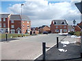
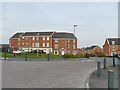
1
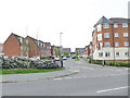
Waggon Road and Oak Drive. New Forest Village, Middleton
Part of a large housing development.
Image: © Stephen Craven
Taken: 10 Apr 2020
0.04 miles
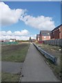
4
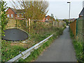
Footpath with crash barrier
The presence of a vehicle crash barrier along a footpath is odd, unless it was once a road wide enough for vehicle traffic. See also Image
Image: © Stephen Craven
Taken: 10 Apr 2020
0.07 miles
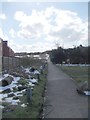
8
Junction of Throstle Road and St George's Road, Middleton
Throstle Road originally ended at the eastern boundary of the 1930s council estate, but has recently been extended eastwards to meet St George's Road, as part of the "New Forest Village" development.
Image: © Stephen Craven
Taken: 10 Apr 2020
0.08 miles
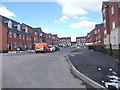
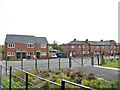
9
Twentyman Walk. New Forest Village, Middleton
Part of a large housing development. Image taken seven years earlier shows these houses just after completion.
Image: © Stephen Craven
Taken: 10 Apr 2020
0.08 miles
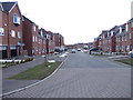
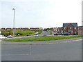
10
New and old housing on Thorpe Road, Middleton
The houses to the right would have been part of the original Middleton council estate of the 1920s/30s; the houses to the left are a much more recent infill development.
Image: © Stephen Craven
Taken: 10 Apr 2020
0.09 miles