IMAGES TAKEN NEAR TO
St. Philips Avenue, LEEDS, LS10 3SL
Introduction
This page details the photographs taken nearby to St. Philips Avenue, LS10 3SL by members of the Geograph project.
The Geograph project started in 2005 with the aim of publishing, organising and preserving representative images for every square kilometre of Great Britain, Ireland and the Isle of Man.

There are currently over 7.5m images from over14,400 individuals and you can help contribute to the project by visiting https://www.geograph.org.uk
Image Map
Images are licensed for reuse under creativecommons.org/licenses/by-sa/2.0
Notes
- Clicking on the map will re-center to the selected point.
- The higher the marker number, the further away the image location is from the centre of the postcode.
Image Listing (117 Images Found)
Images are licensed for reuse under creativecommons.org/licenses/by-sa/2.0
Image
Details
Distance
2
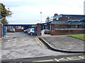
St Philips Catholic Primary School - St Philips Avenue
Image: © Betty Longbottom
Taken: 19 Oct 2012
0.02 miles
3
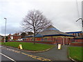
St Philip's Roman Catholic Church, Middleton, Leeds
Image: © Bill Henderson
Taken: 4 Dec 2012
0.04 miles
4
St Philip's Roman Catholic Church, Middleton, Leeds
Image: © Bill Henderson
Taken: 12 Oct 2006
0.06 miles
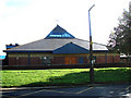
5
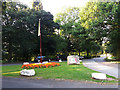
Middleton Park - green flag
The green flag (signifying that the park meets certain standards) flies just inside the south entrance.
Image: © Stephen Craven
Taken: 18 Aug 2016
0.06 miles
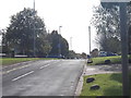
6

Town Street - viewed from New Lane
Image: © Betty Longbottom
Taken: 19 Oct 2012
0.07 miles
10
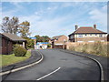
St Philips Close - off Middleton Park Road
Image: © Betty Longbottom
Taken: 19 Oct 2012
0.08 miles