IMAGES TAKEN NEAR TO
Aberfield Gardens, LEEDS, LS10 3QL
Introduction
This page details the photographs taken nearby to Aberfield Gardens, LS10 3QL by members of the Geograph project.
The Geograph project started in 2005 with the aim of publishing, organising and preserving representative images for every square kilometre of Great Britain, Ireland and the Isle of Man.

There are currently over 7.5m images from over14,400 individuals and you can help contribute to the project by visiting https://www.geograph.org.uk
Image Map
Images are licensed for reuse under creativecommons.org/licenses/by-sa/2.0
Notes
- Clicking on the map will re-center to the selected point.
- The higher the marker number, the further away the image location is from the centre of the postcode.
Image Listing (80 Images Found)
Images are licensed for reuse under creativecommons.org/licenses/by-sa/2.0
Image
Details
Distance
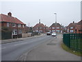
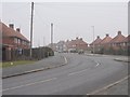
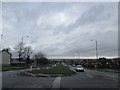
1
Belle Isle Road.
Looking N from near the junction with Middleton Road.
Image: © Steve Partridge
Taken: 26 Feb 2006
0.01 miles
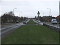
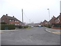
2
Aberfield Gardens - Winrose Approach
Image: © Betty Longbottom
Taken: 5 Mar 2013
0.03 miles
4
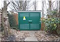
Electricity Substation No 1729 - Winrose Approach
Image: © Betty Longbottom
Taken: 5 Mar 2013
0.05 miles
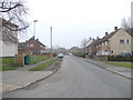
7
Petersfield Avenue, Belle Isle
Presumably named after the nearby St Peter's church rather than the town in Hampshire.
Image: © Stephen Craven
Taken: 21 Feb 2021
0.08 miles
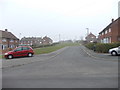
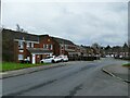
9
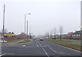
Belle Isle Road - viewed from Aberfield Gate
Image: © Betty Longbottom
Taken: 5 Mar 2013
0.09 miles