IMAGES TAKEN NEAR TO
Broom Nook, LEEDS, LS10 3LR
Introduction
This page details the photographs taken nearby to Broom Nook, LS10 3LR by members of the Geograph project.
The Geograph project started in 2005 with the aim of publishing, organising and preserving representative images for every square kilometre of Great Britain, Ireland and the Isle of Man.

There are currently over 7.5m images from over14,400 individuals and you can help contribute to the project by visiting https://www.geograph.org.uk
Image Map
Images are licensed for reuse under creativecommons.org/licenses/by-sa/2.0
Notes
- Clicking on the map will re-center to the selected point.
- The higher the marker number, the further away the image location is from the centre of the postcode.
Image Listing (59 Images Found)
Images are licensed for reuse under creativecommons.org/licenses/by-sa/2.0
Image
Details
Distance
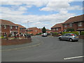
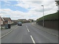
2

Hopes Farm Road - Ring Road, Middleton
Image: © Betty Longbottom
Taken: 25 Jun 2013
0.04 miles
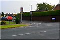
3
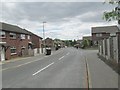
Grange Fields Way - Ring Road, Middleton
Image: © Betty Longbottom
Taken: 25 Jun 2013
0.05 miles

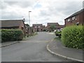
5
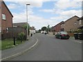
Grange Fields Mount - Grange Fields Way
Image: © Betty Longbottom
Taken: 25 Jun 2013
0.06 miles
6
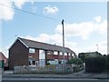
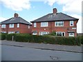
Broom Close, off Broom Mount
More modern houses than those in Broom Terrace, Road and Place.
Image: © Christine Johnstone
Taken: 5 Apr 2012
0.07 miles
7
Houses in Broom Terrace, Belle Isle
One has a protective grille in front of the front door.
Image: © Christine Johnstone
Taken: 5 Apr 2012
0.09 miles
8
Mandarin Way - Ring Road, Middleton
Image: © Betty Longbottom
Taken: 25 Jun 2013
0.09 miles
10
South Hill Gardens - South Hill Way
Image: © Betty Longbottom
Taken: 25 Jun 2013
0.10 miles