IMAGES TAKEN NEAR TO
Royal Court, LEEDS, LS10 2RW
Introduction
This page details the photographs taken nearby to Royal Court, LS10 2RW by members of the Geograph project.
The Geograph project started in 2005 with the aim of publishing, organising and preserving representative images for every square kilometre of Great Britain, Ireland and the Isle of Man.

There are currently over 7.5m images from over14,400 individuals and you can help contribute to the project by visiting https://www.geograph.org.uk
Image Map
Images are licensed for reuse under creativecommons.org/licenses/by-sa/2.0
Notes
- Clicking on the map will re-center to the selected point.
- The higher the marker number, the further away the image location is from the centre of the postcode.
Image Listing (170 Images Found)
Images are licensed for reuse under creativecommons.org/licenses/by-sa/2.0
Image
Details
Distance
9
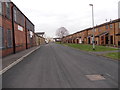
Playfair Road - looking towards Balm Road
Image: © Betty Longbottom
Taken: 22 Feb 2013
0.08 miles
10
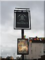
Sign for the Prospect
See Image for context.
Image: © Stephen Craven
Taken: 3 Dec 2022
0.08 miles