IMAGES TAKEN NEAR TO
Lupton Street, LEEDS, LS10 2QR
Introduction
This page details the photographs taken nearby to Lupton Street, LS10 2QR by members of the Geograph project.
The Geograph project started in 2005 with the aim of publishing, organising and preserving representative images for every square kilometre of Great Britain, Ireland and the Isle of Man.

There are currently over 7.5m images from over14,400 individuals and you can help contribute to the project by visiting https://www.geograph.org.uk
Image Map
Images are licensed for reuse under creativecommons.org/licenses/by-sa/2.0
Notes
- Clicking on the map will re-center to the selected point.
- The higher the marker number, the further away the image location is from the centre of the postcode.
Image Listing (101 Images Found)
Images are licensed for reuse under creativecommons.org/licenses/by-sa/2.0
Image
Details
Distance
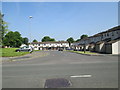
1
Hunslet Church of the Nazarene - Lupton Street
Image: © Betty Longbottom
Taken: 7 Jun 2013
0.04 miles
4
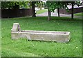
Cattle Trough - end of New Pepper Road
The inscription reads "Metropolitan Drinking Fountain and Cattle Trough Association".
Image: © Betty Longbottom
Taken: 19 May 2008
0.08 miles
5
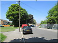
Belinda Street - looking towards Church Street
Image: © Betty Longbottom
Taken: 7 Jun 2013
0.08 miles
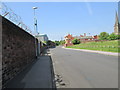
8
Grove Road- looking towards Church Street
Image: © Betty Longbottom
Taken: 7 Jun 2013
0.09 miles