
IMAGES TAKEN NEAR TO
Lupton Street, LEEDS, LS10 2QP
Introduction
This page details the photographs taken nearby to Lupton Street, LS10 2QP by members of the Geograph project.
The Geograph project started in 2005 with the aim of publishing, organising and preserving representative images for every square kilometre of Great Britain, Ireland and the Isle of Man.

There are currently over 7.5m images from over14,400 individuals and you can help contribute to the project by visiting https://www.geograph.org.uk
Image Map
Images are licensed for reuse under creativecommons.org/licenses/by-sa/2.0
Notes
- Clicking on the map will re-center to the selected point.
- The higher the marker number, the further away the image location is from the centre of the postcode.
Image Listing (135 Images Found)
Images are licensed for reuse under creativecommons.org/licenses/by-sa/2.0
Image
Details
Distance
1
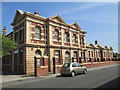
Stringer House Voluntary Action Centre - Lupton Street
Image: © Betty Longbottom
Taken: 7 Jun 2013
0.01 miles
3
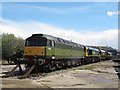
Beeching's Legacy
This class 47 loco, official (TOPS) number 47830, has been repainted in original livery, renumbered D1645 (as it originally was) and named "Beeching's Legacy". Seen at Freightliner's Hunslet depot.
Image: © Stephen Craven
Taken: 30 Apr 2016
0.05 miles
4
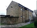
St Mary's Church, Hunslet: former vicarage
The vicarage is contemporary with the 1970s church but is currently used as overflow accommodation by the adjacent church school; the church is served by clergy from a neighbouring parish.
Image: © Stephen Craven
Taken: 21 Jan 2016
0.06 miles
5
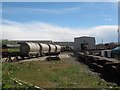
Hunslet Freightliner depot (1)
A couple of rows of wagons at the north end of the site adjacent to Midland Road.
Image: © Stephen Craven
Taken: 30 Apr 2016
0.06 miles
7
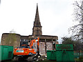
Start of demolition of St Mary's church, Hunslet
The church has been officially closed since my first photo of it three years earlier Image, and permission was recently given to demolish the modern (1975) part of the building. This view shows the wall construction - stone outer skin, brick inner skin, with polystyrene cavity insulation.
The spire which is listed grade 2 (list entry 1255563) will remain. The 19th century church of which it was part would have extended into the area occupied by the contractor's plant in this view.
Image: © Stephen Craven
Taken: 4 Apr 2019
0.06 miles
10
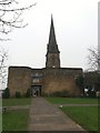
St Mary's Church, Hunslet
The Anglican church here has a history going back to c.1630 but the tall spire visible here which dominates the area is all that is left of the Victorian church of 1862-4 by local architects Perkins and Backhouse. It is listed grade 2 (list entry 1255563). The lower and more modern building in front is the current church of c.1975 by Peter Hill.
Image: © Stephen Craven
Taken: 21 Jan 2016
0.06 miles