IMAGES TAKEN NEAR TO
Larchfield Road, LEEDS, LS10 1QP
Introduction
This page details the photographs taken nearby to Larchfield Road, LS10 1QP by members of the Geograph project.
The Geograph project started in 2005 with the aim of publishing, organising and preserving representative images for every square kilometre of Great Britain, Ireland and the Isle of Man.

There are currently over 7.5m images from over14,400 individuals and you can help contribute to the project by visiting https://www.geograph.org.uk
Image Map
Images are licensed for reuse under creativecommons.org/licenses/by-sa/2.0
Notes
- Clicking on the map will re-center to the selected point.
- The higher the marker number, the further away the image location is from the centre of the postcode.
Image Listing (181 Images Found)
Images are licensed for reuse under creativecommons.org/licenses/by-sa/2.0
Image
Details
Distance
3
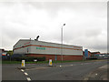
Briggate Garage, National Road, Leeds
Motor vehicle repairs, MOTs and servicing.
Image: © Stephen Craven
Taken: 29 Oct 2016
0.04 miles
4
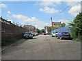
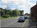
Larchfield Road - viewed from Forster Street
Image: © Betty Longbottom
Taken: 3 Jun 2013
0.05 miles
5
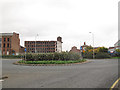
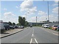
Goodman Street roundabout, Leeds
The buildings in the distance are former factories along the riverside.
Image: © Stephen Craven
Taken: 29 Oct 2016
0.05 miles
6
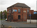
Goodman House, Larchfield Street, Leeds
Home of CBM, a construction company. The building is one of the older ones in the area, and was originally the Goodman pub. The pub was described in a CAMRA guide to Leeds pubs published in 1993 as a Tetley's house, still open then but according to Secretleeds.com, it closed not long afterwards.
Image: © Stephen Craven
Taken: 29 Oct 2016
0.05 miles
7
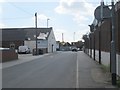
Goodman Street - viewed from Larchfield Road
Image: © Betty Longbottom
Taken: 3 Jun 2013
0.05 miles
8
No Parking on Goodman Street
Painted on the south wall of Hunslet mill.
Image: © Steve Partridge
Taken: 21 Oct 2007
0.05 miles
9
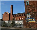
Hunslet Mill (2)
Built in 1838-40 for steam-powered flax spinning, with extensive additions from 1840-50 when a new warehouse and boiler house were added. Most of the additions were demolished but the main mill was saved by listing (Grade II*). Proposals have been made for development as part of a regeneration scheme for the area into a landscaped business park.
Image: © Steve Partridge
Taken: 21 Oct 2007
0.05 miles
10
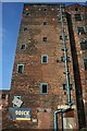
Hunslet Mill (3)
Built in 1838-40 for steam-powered flax spinning, with extensive additions from 1840-50 when a new warehouse and boiler house were added. Most of the additions were demolished but the main mill was saved by listing (Grade II*). Proposals have been made for development as part of a regeneration scheme for the area into a landscaped business park. Viewed from Goodman Street.
Image: © Steve Partridge
Taken: 21 Oct 2007
0.05 miles