IMAGES TAKEN NEAR TO
Cable Place, LEEDS, LS10 1GB
Introduction
This page details the photographs taken nearby to Cable Place, LS10 1GB by members of the Geograph project.
The Geograph project started in 2005 with the aim of publishing, organising and preserving representative images for every square kilometre of Great Britain, Ireland and the Isle of Man.

There are currently over 7.5m images from over14,400 individuals and you can help contribute to the project by visiting https://www.geograph.org.uk
Image Map
Images are licensed for reuse under creativecommons.org/licenses/by-sa/2.0
Notes
- Clicking on the map will re-center to the selected point.
- The higher the marker number, the further away the image location is from the centre of the postcode.
Image Listing (146 Images Found)
Images are licensed for reuse under creativecommons.org/licenses/by-sa/2.0
Image
Details
Distance
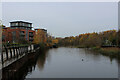
2
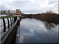
Stub of the old River Aire at Knostrop Cut
When the Knostrop Cut was formed in 18xx as part of the Aire and Calder Navigation, it was a shortcut to the north of the meandering course of the Aire. Subsequently (some time in the second half of the 19th century) a new cut was made for the river itself running parallel and to the north of the Navigation. This short stub is all that remains; another contributor notes Image that at one time it served an oil terminal. The rest of the old course of the Aire from here to the other end of the Cut is no longer visible: it probably still exists in culvert, as there is a small outfall at the far end.
Image: © Stephen Craven
Taken: 18 Feb 2017
0.03 miles
3
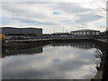
The basin of the former Leeds oil terminal
One side is currently being redeveloped as riverside housing.
Image: © Christine Johnstone
Taken: 15 Jan 2012
0.03 miles
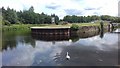
4
Aire and Calder stub
A dead end section of canal. A swan and cygnets are amongst the reeds.
Image: © DS Pugh
Taken: 26 May 2023
0.03 miles
5
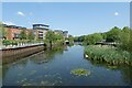
Looking North up the River Aire
Heading towards Leeds City Centre
Image: © Chris Heaton
Taken: 27 Nov 2022
0.04 miles
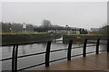
6

Short offshoot of the River Aire in Leeds
Image: © Mat Fascione
Taken: 4 Aug 2017
0.05 miles
7
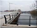
Knostrop Flood Lock on the Aire and Calder Navigation
At this point the navigation splits from the River Aire and is canalised to the south of the river.
Image: © Graham Hogg
Taken: 8 Mar 2013
0.05 miles
8
Cummins, Old Mill Lane, Leeds
Distributors of diesel engines.
Image: © Stephen Craven
Taken: 7 Dec 2016
0.06 miles
9
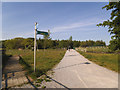
Approach to the new bridge, Knostrop Cut
Following the completion of flood alleviation works that removed the 'central reservation' between the river and the Navigation, the cycle route (National route 67) that used to run along the reservation and that was temporarily diverted round roads on the south bank was reinstated in 2019 along the north bank of the river, with a new bridge at each end. This is the approach to the western bridge from the south side.
See Image for the old bridge that this one replaced.
Image: © Stephen Craven
Taken: 14 May 2019
0.06 miles
10
Looking towards Knostrop Cut from South bank
Image: © Darren Haddock
Taken: 12 Jul 2019
0.06 miles