IMAGES TAKEN NEAR TO
Islip Court, HORNCASTLE, LN9 6RG
Introduction
This page details the photographs taken nearby to Islip Court, LN9 6RG by members of the Geograph project.
The Geograph project started in 2005 with the aim of publishing, organising and preserving representative images for every square kilometre of Great Britain, Ireland and the Isle of Man.

There are currently over 7.5m images from over14,400 individuals and you can help contribute to the project by visiting https://www.geograph.org.uk
Image Map
Images are licensed for reuse under creativecommons.org/licenses/by-sa/2.0
Notes
- Clicking on the map will re-center to the selected point.
- The higher the marker number, the further away the image location is from the centre of the postcode.
Image Listing (20 Images Found)
Images are licensed for reuse under creativecommons.org/licenses/by-sa/2.0
Image
Details
Distance
8

Spilsby Road Mill
Former 5-sailed and originally 7-storey tower mill built in 1843, possibly on the site of an earlier mill. The mill was tail-winded around 1916 and the resultant damage required the removal of the top 2-storeys. Milling continued until 1972 using an auxiliary engine. http://www.lincolnshire.gov.uk/windmills/section.asp?catId=3339
Image: © Richard Croft
Taken: 28 Mar 2007
0.14 miles

10
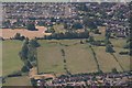
River Waring and ditched site NE of Horncastle: aerial 2018
Image: © Chris
Taken: 30 Jun 2018
0.18 miles