IMAGES TAKEN NEAR TO
Clay Lane, HORNCASTLE, LN9 6QN
Introduction
This page details the photographs taken nearby to Clay Lane, LN9 6QN by members of the Geograph project.
The Geograph project started in 2005 with the aim of publishing, organising and preserving representative images for every square kilometre of Great Britain, Ireland and the Isle of Man.

There are currently over 7.5m images from over14,400 individuals and you can help contribute to the project by visiting https://www.geograph.org.uk
Image Map
Images are licensed for reuse under creativecommons.org/licenses/by-sa/2.0
Notes
- Clicking on the map will re-center to the selected point.
- The higher the marker number, the further away the image location is from the centre of the postcode.
Image Listing (3 Images Found)
Images are licensed for reuse under creativecommons.org/licenses/by-sa/2.0
Image
Details
Distance
1
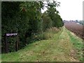
Footpath near Little London
The footpath used to run onwards from Clay Lane, but it now follows the Bridle Path and as the sign states, restart again in 1000yds.
Image: © Dave Hitchborne
Taken: 5 Oct 2007
0.18 miles
2
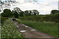
Across the drain to Oester Dale and Dodd's Wood
Image: © Chris
Taken: 11 May 2014
0.19 miles
3
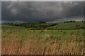
Family walk in Clay Lane on a stormy Sunday afternoon
Image: © Chris
Taken: 11 May 2014
0.22 miles