IMAGES TAKEN NEAR TO
Scrafield, HORNCASTLE, LN9 6PA
Introduction
This page details the photographs taken nearby to LN9 6PA by members of the Geograph project.
The Geograph project started in 2005 with the aim of publishing, organising and preserving representative images for every square kilometre of Great Britain, Ireland and the Isle of Man.

There are currently over 7.5m images from over14,400 individuals and you can help contribute to the project by visiting https://www.geograph.org.uk
Image Map
Images are licensed for reuse under creativecommons.org/licenses/by-sa/2.0
Notes
- Clicking on the map will re-center to the selected point.
- The higher the marker number, the further away the image location is from the centre of the postcode.
Image Listing (8 Images Found)
Images are licensed for reuse under creativecommons.org/licenses/by-sa/2.0
Image
Details
Distance
1
Autumn sown crop and Scrafield House Farm
Image: © Jonathan Thacker
Taken: 3 Feb 2022
0.06 miles
2
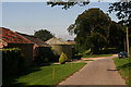
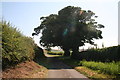
Road through Scrafield
Some fine beech trees leading away from the farm and Scrafield House.
Image: © Chris
Taken: 23 Jul 2014
0.11 miles
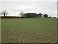
4
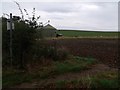
Footpath across the field to Westmoor Plantation
Image: © J.Hannan-Briggs
Taken: 9 Oct 2011
0.14 miles
5
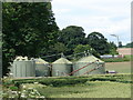
Silos near Scrafield House
Check out the unusual tree in the background.
Image: © Ian Paterson
Taken: 27 Jun 2007
0.15 miles
7
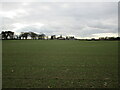
Autumn sown crop and woodland at Scrafield
The church of St. Michael stood on this ridge until 1842. The graveyard still exists behind the trees in the centre of the picture.
Image: © Jonathan Thacker
Taken: 3 Feb 2022
0.20 miles
8
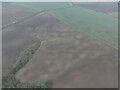
Soilmarks on a field at Scrafield: aerial 2022
Image: © Simon Tomson
Taken: 23 Jan 2022
0.25 miles