IMAGES TAKEN NEAR TO
Narrow Lane, HORNCASTLE, LN9 6LE
Introduction
This page details the photographs taken nearby to Narrow Lane, LN9 6LE by members of the Geograph project.
The Geograph project started in 2005 with the aim of publishing, organising and preserving representative images for every square kilometre of Great Britain, Ireland and the Isle of Man.

There are currently over 7.5m images from over14,400 individuals and you can help contribute to the project by visiting https://www.geograph.org.uk
Image Map
Images are licensed for reuse under creativecommons.org/licenses/by-sa/2.0
Notes
- Clicking on the map will re-center to the selected point.
- The higher the marker number, the further away the image location is from the centre of the postcode.
Image Listing (27 Images Found)
Images are licensed for reuse under creativecommons.org/licenses/by-sa/2.0
Image
Details
Distance
1
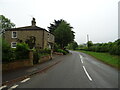
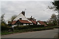
Narrow Lane, Belchford
Narrow Lane is not just a description, it is also the name of this little back lane.
Image: © Tony Atkin
Taken: 8 Nov 2008
0.04 miles
2
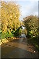
The Road to Glebe Hill
Looking along the road which leads out of the village of Belchford in an easterly direction.
Image: © Tony Atkin
Taken: 8 Nov 2008
0.08 miles
3
Optical illusion house in Belchford
Dial Cottage. It looks like an optical illusion or one of those "impossible" pictures, but this is for real. The unusual angles seem to have been created to fit into the restricted plot.
Image: © Chris
Taken: 10 Apr 2014
0.08 miles
4
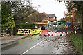
Bridge Repairs
At the centre of the village the road crosses a stream and the bridge is in need of replacement. These roadworks blocked all vehicular traffic for a couple of months and the only way around is a detour of several miles.
Image: © Tony Atkin
Taken: 8 Nov 2008
0.12 miles
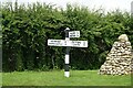
6
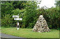
Fingerpost and cairn on Main Road, Belchford
Image: © JThomas
Taken: 12 Jun 2020
0.13 miles
7

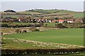
Ridge and furrow in Belchford: aerial 2014
The River Waring runs along the left edge of the field.
Lowfield Lane leads to the right off the top of the field, with Eastfield farm and its irrigation reservoir at the top of the picture.
Image: © Chris
Taken: 2 Jan 2014
0.14 miles
8
Direction Sign ? Signpost on Main Road in Belchford
Located on the north side of the T junction of Main Road and Fulletby Road in Belchford parish. 3 arms and no finial.
Milestone Society National ID: LI_TF2975
Image: © A Riley
Taken: 7 Jul 2021
0.14 miles