IMAGES TAKEN NEAR TO
Main Road, HORNCASTLE, LN9 6JQ
Introduction
This page details the photographs taken nearby to Main Road, LN9 6JQ by members of the Geograph project.
The Geograph project started in 2005 with the aim of publishing, organising and preserving representative images for every square kilometre of Great Britain, Ireland and the Isle of Man.

There are currently over 7.5m images from over14,400 individuals and you can help contribute to the project by visiting https://www.geograph.org.uk
Image Map
Images are licensed for reuse under creativecommons.org/licenses/by-sa/2.0
Notes
- Clicking on the map will re-center to the selected point.
- The higher the marker number, the further away the image location is from the centre of the postcode.
Image Listing (66 Images Found)
Images are licensed for reuse under creativecommons.org/licenses/by-sa/2.0
Image
Details
Distance
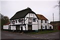
1
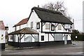
Marmion Arms
The 16th century Marmion Arms http://www.geograph.org.uk/photo/85764 in less prosperous times
Image: © Richard Croft
Taken: 22 Feb 2010
0.12 miles
2
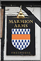
The sign of the Marmion Arms
One of the signs on the now-closed Marmion Arms http://www.geograph.org.uk/photo/1721868
Image: © Richard Croft
Taken: 22 Feb 2010
0.12 miles
3
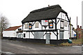
Marmion Arms
Former free-house pub http://www.geograph.org.uk/photo/85764 with 16th century origins, now closed
Image: © Richard Croft
Taken: 22 Feb 2010
0.12 miles
4
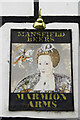
The sign of the Marmion Arms
Fading and peeling .... one of the signs on The Marmion Arms http://www.geograph.org.uk/photo/1721868
Image: © Richard Croft
Taken: 22 Feb 2010
0.13 miles
5
Marmion Arms
16th century thatched inn that used to be on the main road
Image: © Richard Croft
Taken: Unknown
0.14 miles
6
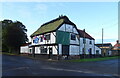
The former Marmion Arms, Haltham
Now a private residence.
Image: © JThomas
Taken: 1 Oct 2020
0.14 miles


10
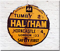
Old circular AA Sign on Church Lane in Haltham
Old AA Sign on a low white painted building on Church Lane in Haltham, 4 miles southwest of Horncastle. Haltham parish.
This is the circular, village name on black band, no Motor Union symbol or name type, dating from 1923, and showing distances Tumby 2½ Horncastle 4 London 133. Not visible on Google Street View.
There were five series of AA signs, mostly dating from 1923 and made by Francis & Co / Franco in Deptford, London. The village name and distance to London were displayed.
Milestone Society National ID: LI-HALTH
Image: © Milestone Society
Taken: Unknown
0.18 miles