IMAGES TAKEN NEAR TO
Boston Road, HORNCASTLE, LN9 6JN
Introduction
This page details the photographs taken nearby to Boston Road, LN9 6JN by members of the Geograph project.
The Geograph project started in 2005 with the aim of publishing, organising and preserving representative images for every square kilometre of Great Britain, Ireland and the Isle of Man.

There are currently over 7.5m images from over14,400 individuals and you can help contribute to the project by visiting https://www.geograph.org.uk
Image Map
Images are licensed for reuse under creativecommons.org/licenses/by-sa/2.0
Notes
- Clicking on the map will re-center to the selected point.
- The higher the marker number, the further away the image location is from the centre of the postcode.
Image Listing (11 Images Found)
Images are licensed for reuse under creativecommons.org/licenses/by-sa/2.0
Image
Details
Distance
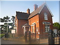
1
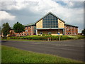
The Mortons building on Boston Road, Horncastle
Image: © Ian S
Taken: 19 Aug 2012
0.04 miles
2
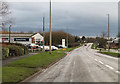
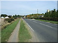
A153 Boston Road, Horncastle
Heading south out of Horncastle.
Image: © J.Hannan-Briggs
Taken: 6 Dec 2015
0.04 miles
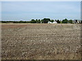
3
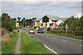
Approaching Horncastle from the South
New commercial buildings are prominent to the right of the road.
Image: © Tony Atkin
Taken: 7 Sep 2006
0.06 miles
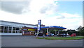
9
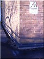
Cut Mark: Horncastle, pumping station, Thornton road
Cut bench mark on the pumping station on the road from the A153 towards Thornton. See http://www.bench-marks.org.uk/bm49713 for details.
Image: © Brian Westlake
Taken: 29 Nov 2012
0.20 miles
10
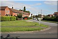
Lancaster Gardens, Horncastle
A post-war housing estate.
Image: © Tony Atkin
Taken: 7 Sep 2006
0.21 miles