IMAGES TAKEN NEAR TO
Scrivelsby, HORNCASTLE, LN9 6JL
Introduction
This page details the photographs taken nearby to LN9 6JL by members of the Geograph project.
The Geograph project started in 2005 with the aim of publishing, organising and preserving representative images for every square kilometre of Great Britain, Ireland and the Isle of Man.

There are currently over 7.5m images from over14,400 individuals and you can help contribute to the project by visiting https://www.geograph.org.uk
Image Map
Images are licensed for reuse under creativecommons.org/licenses/by-sa/2.0
Notes
- Clicking on the map will re-center to the selected point.
- The higher the marker number, the further away the image location is from the centre of the postcode.
Image Listing (9 Images Found)
Images are licensed for reuse under creativecommons.org/licenses/by-sa/2.0
Image
Details
Distance
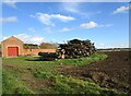
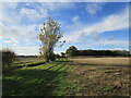
4
Stubble field near Scrivelsby Grange
Dalderby Plantation in the distance.
Image: © Jonathan Thacker
Taken: 25 Oct 2020
0.17 miles
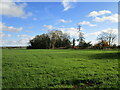
5
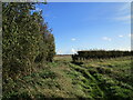
Corner of a field near Scrivelsby Grange
The bridleway follows the line of the hedge to the right.
Image: © Jonathan Thacker
Taken: 25 Oct 2020
0.20 miles
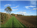
6
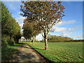
Roadway from Scrivelsby Grange
Whoops! I was so busy watching three buzzards circling overhead that coming from the main road I completely missed the point where the bridleway leaves this roadway.
Image: © Jonathan Thacker
Taken: 25 Oct 2020
0.21 miles
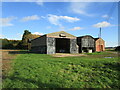
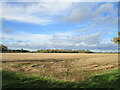
7
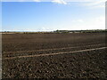
Prepared field near Scrivelsby Grange
Looking in the general direction of Wood Enderby.
Image: © Jonathan Thacker
Taken: 25 Oct 2020
0.21 miles