IMAGES TAKEN NEAR TO
Main Road, HORNCASTLE, LN9 6JE
Introduction
This page details the photographs taken nearby to Main Road, LN9 6JE by members of the Geograph project.
The Geograph project started in 2005 with the aim of publishing, organising and preserving representative images for every square kilometre of Great Britain, Ireland and the Isle of Man.

There are currently over 7.5m images from over14,400 individuals and you can help contribute to the project by visiting https://www.geograph.org.uk
Image Map
Images are licensed for reuse under creativecommons.org/licenses/by-sa/2.0
Notes
- Clicking on the map will re-center to the selected point.
- The higher the marker number, the further away the image location is from the centre of the postcode.
Image Listing (7 Images Found)
Images are licensed for reuse under creativecommons.org/licenses/by-sa/2.0
Image
Details
Distance
1
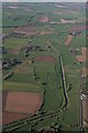
River Bain northwards, passing Haltham: aerial
Image: © Chris
Taken: 25 Mar 2017
0.15 miles
2
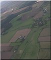
Horncastle Canal and Old River Bain near Haltham: aerial 2020
Image: © Chris
Taken: 30 Aug 2020
0.17 miles
3
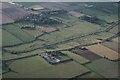
River Bain and disused Horncastle Canal N of Haltham: aerial 2022
Image: © Chris
Taken: 28 Sep 2022
0.17 miles
4

Dry Ford on Old River Bain, Roughton
This ford is found on the farm track approaching the disused Horncastle Canal near the A153.
Image: © John Walton
Taken: 7 May 2010
0.19 miles
5

Altar and East window, St Margaret's church, Roughton
Image: © Julian P Guffogg
Taken: 9 Sep 2018
0.22 miles
6
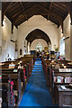
Interior, St Margaret's church, Roughton
Image: © Julian P Guffogg
Taken: 9 Sep 2018
0.22 miles
7
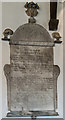
Memorial to Norreys Fynes, St Margaret church, Roughton
Died 1735-6.
He married Elizabeth Kendal and they had 12 children, of which 5 died in infancy.
Image: © Julian P Guffogg
Taken: 9 Sep 2018
0.22 miles