IMAGES TAKEN NEAR TO
Dalderby, HORNCASTLE, LN9 6JD
Introduction
This page details the photographs taken nearby to LN9 6JD by members of the Geograph project.
The Geograph project started in 2005 with the aim of publishing, organising and preserving representative images for every square kilometre of Great Britain, Ireland and the Isle of Man.

There are currently over 7.5m images from over14,400 individuals and you can help contribute to the project by visiting https://www.geograph.org.uk
Image Map
Images are licensed for reuse under creativecommons.org/licenses/by-sa/2.0
Notes
- Clicking on the map will re-center to the selected point.
- The higher the marker number, the further away the image location is from the centre of the postcode.
Image Listing (24 Images Found)
Images are licensed for reuse under creativecommons.org/licenses/by-sa/2.0
Image
Details
Distance
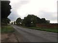
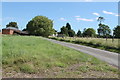
4
A153 heading south at Dalderby
Towards Sleaford.
Image: © JThomas
Taken: 28 Sep 2013
0.04 miles
7
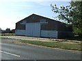
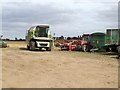
Manor Farm, Dalderby
The usual farm 'clutter'.
Image: © Dave Hitchborne
Taken: 14 Sep 2007
0.15 miles
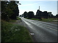
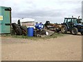
10
Manor Farm, Dalderby
The combine harvester has become redundant until next year. Seems a shame that these can't be employed to do other jobs, such as ploughing. One day, maybe.
Image: © Dave Hitchborne
Taken: 14 Sep 2007
0.16 miles