IMAGES TAKEN NEAR TO
Coronation Walk, HORNCASTLE, LN9 6HP
Introduction
This page details the photographs taken nearby to Coronation Walk, LN9 6HP by members of the Geograph project.
The Geograph project started in 2005 with the aim of publishing, organising and preserving representative images for every square kilometre of Great Britain, Ireland and the Isle of Man.

There are currently over 7.5m images from over14,400 individuals and you can help contribute to the project by visiting https://www.geograph.org.uk
Image Map
Images are licensed for reuse under creativecommons.org/licenses/by-sa/2.0
Notes
- Clicking on the map will re-center to the selected point.
- The higher the marker number, the further away the image location is from the centre of the postcode.
Image Listing (328 Images Found)
Images are licensed for reuse under creativecommons.org/licenses/by-sa/2.0
Image
Details
Distance
1
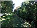
Not the Viking Way
This pleasant path alongside a stream running south from Horncastle is not (we discovered a little later) the Viking Way.
Image: © Tim Heaton
Taken: 14 Sep 2011
0.04 miles
2
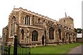
St.Mary's church, Horncastle, Lincs.
A grand church worthy of the town. Largely Decorated & Perpendicular, the Early English tower is spoilt by the tiny spire.
Image: © Richard Croft
Taken: Unknown
0.05 miles
3
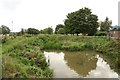
Old River Bain
The Old River Bain seen from The Staunch, silted up and overgrown.
Image: © Richard Croft
Taken: 15 Sep 2008
0.05 miles
4
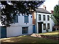
The Old Workhouse and the Old Dispensary, Horncastle
These two buildings can be found next to the Parish Church. The Workhouse was in use from 1735 to 1837 and the Dispensary gave 'Medical Aid to the Poor' between 1789 and 1866.
Image: © Geoff Pick
Taken: 30 Jul 2006
0.07 miles
5
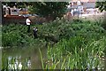
Fishing
This is at the confluence of the River Waring and the River Bain in Horncastle.
Image: © Tony Atkin
Taken: 7 Sep 2006
0.07 miles
6
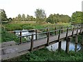
Footbridge over the Horncastle Canal
The Horncastle Canal alongside ran from the River Witham up to Horncastle. It was a broad canal with locks capable of taking boats of 15 ft beam. Fully opened from 1802, it was never a great success and the last commercial traffic ceased in 1910. There is some interest in restoring the canal to full working order.
Immediately north (left) of the footbridge, the River Bain enters from the left, whilst the canal bends right to reach the town centre.
Image: © Oliver Dixon
Taken: 7 Oct 2012
0.07 miles
7
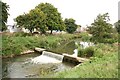
Horncastle Navigation Canal
Weir on the disused Horncastle Canal
Image: © Richard Croft
Taken: 15 Sep 2008
0.08 miles
8
Horncastle weir
Weir on the disused Horncastle Navigation Canal
Image: © Richard Croft
Taken: 21 Aug 2011
0.08 miles
9
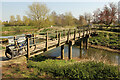
Horncastle Canal footbridge
Footbridge over the long disused Horncastle Navigation Canal.
Image: © Richard Croft
Taken: 19 Apr 2021
0.08 miles
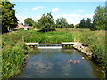
10
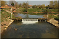
Weir on the Horncastle Canal
Weir on the long disused 11-mile Horncastle Canal between the River Witham and Horncastle. Opened in 1809, abandoned in 1889
Image: © Richard Croft
Taken: 19 Apr 2021
0.08 miles