IMAGES TAKEN NEAR TO
Mareham Road, HORNCASTLE, LN9 6DA
Introduction
This page details the photographs taken nearby to Mareham Road, LN9 6DA by members of the Geograph project.
The Geograph project started in 2005 with the aim of publishing, organising and preserving representative images for every square kilometre of Great Britain, Ireland and the Isle of Man.

There are currently over 7.5m images from over14,400 individuals and you can help contribute to the project by visiting https://www.geograph.org.uk
Image Map
Images are licensed for reuse under creativecommons.org/licenses/by-sa/2.0
Notes
- Clicking on the map will re-center to the selected point.
- The higher the marker number, the further away the image location is from the centre of the postcode.
Image Listing (28 Images Found)
Images are licensed for reuse under creativecommons.org/licenses/by-sa/2.0
Image
Details
Distance
1
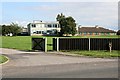
Banovallum School
This school caters for 11 to 16 year olds and was built in the early 1960's. The name Banovallum is thought by some to be the Roman name for the town but no-one knows for sure!
Image: © Tony Atkin
Taken: 7 Sep 2006
0.06 miles
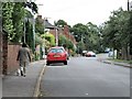
3
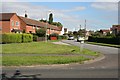
Lancaster Gardens, Horncastle
A post-war housing estate.
Image: © Tony Atkin
Taken: 7 Sep 2006
0.17 miles
4
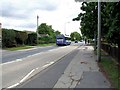
Boston Road, Horncastle
A Brylaine route 7 bus heads in the direction of Boston, probably from Skegness. Brylaine are Bryan and Elaine who once lived in Old Bolingbroke. I forget their surname, but will add it when I remember.
As viewed from outside the former Town Hall.
Image: © Dave Hitchborne
Taken: 18 Jul 2009
0.22 miles
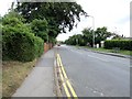
5
Boston Road, Horncastle
At the former Town Hall is this pedestrian crossing, which has the Belisha beacons with the illuminated poles.
The road leads to Coningsby and onwards to Boston or Sleaford.
Image: © Dave Hitchborne
Taken: 18 Jul 2009
0.22 miles
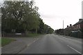
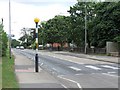
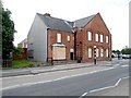
7
Mareham Road, Horncastle
In the distance, to the left and in amongst the trees, is the Horncastle Residential College and Horncastle Ambulance Station.
Image: © Dave Hitchborne
Taken: 18 Jul 2009
0.22 miles
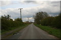
8
Mareham Road, Horncastle
The road takes you to Mareham on the Hill and on a pretty, but winding route to East Kirkby.
Photographed at Hangman's Corner.
Image: © Dave Hitchborne
Taken: 18 Jul 2009
0.22 miles
9
Former Town Hall, Horncastle
Both the East Lindsey District Council and the Horncastle Town Council vacated the building in October 2008. The building was still used for functions, but this has now ceased. There are efforts to keep and use the building, but talk is of demolition, it being surplus to requirements.
Watch this space, as they say. More about the building - http://www.geograph.org.uk/photo/1409136
Image: © Dave Hitchborne
Taken: 18 Jul 2009
0.23 miles
10
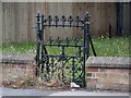
Former Town Hall, Horncastle
Unused gateway, by the Town Hall.
Image: © Dave Hitchborne
Taken: 18 Jul 2009
0.23 miles