IMAGES TAKEN NEAR TO
Devereux Way, HORNCASTLE, LN9 6AU
Introduction
This page details the photographs taken nearby to Devereux Way, LN9 6AU by members of the Geograph project.
The Geograph project started in 2005 with the aim of publishing, organising and preserving representative images for every square kilometre of Great Britain, Ireland and the Isle of Man.

There are currently over 7.5m images from over14,400 individuals and you can help contribute to the project by visiting https://www.geograph.org.uk
Image Map
Images are licensed for reuse under creativecommons.org/licenses/by-sa/2.0
Notes
- Clicking on the map will re-center to the selected point.
- The higher the marker number, the further away the image location is from the centre of the postcode.
Image Listing (4 Images Found)
Images are licensed for reuse under creativecommons.org/licenses/by-sa/2.0
Image
Details
Distance
2
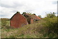
Derelict farm buildings on the road to Mareham on the Hill
On the outskirts of Horncastle, though maybe not for long since the battle is raging over a proposed large housing development on the fields behind.
See also Image
Image: © Chris
Taken: 28 Apr 2016
0.19 miles
3
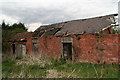
Derelict farm buildings on the road to Mareham on the Hill
On the outskirts of Horncastle, though maybe not for long since the battle is raging over a proposed large housing development on the fields behind.
See also Image
Image: © Chris
Taken: 28 Apr 2016
0.19 miles