IMAGES TAKEN NEAR TO
Billy English Way, HORNCASTLE, LN9 5UB
Introduction
This page details the photographs taken nearby to Billy English Way, LN9 5UB by members of the Geograph project.
The Geograph project started in 2005 with the aim of publishing, organising and preserving representative images for every square kilometre of Great Britain, Ireland and the Isle of Man.

There are currently over 7.5m images from over14,400 individuals and you can help contribute to the project by visiting https://www.geograph.org.uk
Image Map
Images are licensed for reuse under creativecommons.org/licenses/by-sa/2.0
Notes
- Clicking on the map will re-center to the selected point.
- The higher the marker number, the further away the image location is from the centre of the postcode.
Image Listing (28 Images Found)
Images are licensed for reuse under creativecommons.org/licenses/by-sa/2.0
Image
Details
Distance
3
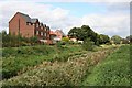
Site of Horncastle station
View westward in Station Lane: terminus of the ex-GNR branch from Woodhall Junction, which closed finally 5/4/71, passenger services having ceased from 12/9/54 - a depressing scene?
Image: © Ben Brooksbank
Taken: 26 Jun 1997
0.12 miles
4
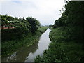
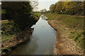
The River Bain
The original course of the River was just to the east of its present position. The straightness of this course betrays its origin as part of the Horncastle Canal.
Image: © Jonathan Thacker
Taken: 7 Jun 2014
0.12 miles
5
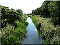
Horncastle Navigation Canal
Remnant of the long-disused, 11-mile Horncastle Canal, between the River Witham and Horncastle. Opened in 1809, abandoned in 1889. Contrast with the same view 13 years ago http://www.geograph.org.uk/photo/964509
Image: © Richard Croft
Taken: 19 Apr 2021
0.12 miles
6
Horncastle Navigation Canal
Remnant of the long-disused, 11-mile Horncastle Canal, between the River Witham and Horncastle. Opened in 1809, abandoned in 1889.
Image: © Richard Croft
Taken: 21 Aug 2011
0.13 miles
7
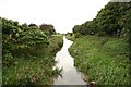
Horncastle Navigation Canal
Looking south on the disused Horncastle Canal
Image: © Richard Croft
Taken: 15 Sep 2008
0.13 miles
8
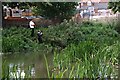
Fishing
This is at the confluence of the River Waring and the River Bain in Horncastle.
Image: © Tony Atkin
Taken: 7 Sep 2006
0.14 miles
9
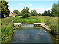
Horncastle weir
Weir on the disused Horncastle Navigation Canal
Image: © Richard Croft
Taken: 21 Aug 2011
0.15 miles
10
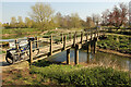
Horncastle Canal footbridge
Footbridge over the long disused Horncastle Navigation Canal.
Image: © Richard Croft
Taken: 19 Apr 2021
0.15 miles