IMAGES TAKEN NEAR TO
Church Lane, HORNCASTLE, LN9 5RS
Introduction
This page details the photographs taken nearby to Church Lane, LN9 5RS by members of the Geograph project.
The Geograph project started in 2005 with the aim of publishing, organising and preserving representative images for every square kilometre of Great Britain, Ireland and the Isle of Man.

There are currently over 7.5m images from over14,400 individuals and you can help contribute to the project by visiting https://www.geograph.org.uk
Image Map
Images are licensed for reuse under creativecommons.org/licenses/by-sa/2.0
Notes
- Clicking on the map will re-center to the selected point.
- The higher the marker number, the further away the image location is from the centre of the postcode.
Image Listing (95 Images Found)
Images are licensed for reuse under creativecommons.org/licenses/by-sa/2.0
Image
Details
Distance
1
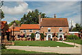
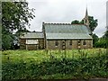
The Sebastopol Inn, Minting, Lincolnshire
Image: © Gary Brothwell
Taken: 19 Aug 2010
0.03 miles
2
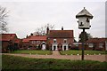
Sebastopol Inn and dovecote
Inn http://www.geograph.org.uk/photo/644977 and dovecote in Minting
Image: © Richard Croft
Taken: 31 Dec 2007
0.03 miles
3
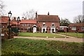
Sebastopol Inn
The oldest parts of this popular hostelry are reputedly 16th century and was a coaching inn en-route to the coast. Local tradition is that the inn was called 'The Beer House' until 1855 when the magistrate conducting the inquest of a man drowned in the beck insisted that it be given a proper name and the contemporary Crimean War siege of Sebastopol provided the inspiration.
Image: © Richard Croft
Taken: 31 Dec 2007
0.03 miles
4
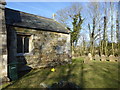
Eastern end of the church
The eastern end, housing the choir and altar, is of far rougher construction than the main body of the church.
Image: © Bob Harvey
Taken: 7 Mar 2015
0.04 miles
5
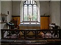
Interior of the Church of St Andrew, Minting
The chancel - The origins of the Grade 2* listed church date from around 1200 with additions in the 15th century, but mostly it comprises an 1863 restoration, a date which can be found on the rainwater hoppers.
Image: © Dave Hitchborne
Taken: 24 Aug 2004
0.04 miles
6
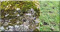
Ordnance Survey Cut Mark
This OS cut mark can be found on the east face of St Andrew's Church. It marks a point 20.854m above mean sea level.
Image: © Adrian Dust
Taken: 23 Jul 2017
0.04 miles
8
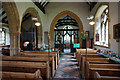
Church Interior
There being no time to track down the keyholder during my visit to Minting, I resorted to plan B, cleaning the outside of a pane in the window, and pressing the camera lens against it.
I am not sure what to make of the arcade. It is neither pointed nor round topped, but some sort of hybrid of the two.
Image: © Bob Harvey
Taken: 7 Mar 2015
0.04 miles
9
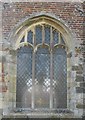
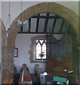
East Window
The east window, which seems to have been reglazed in the Victorian era, has no pictures or images, but has three 'bulls eye' roundels unusual in church windows.
Image: © Bob Harvey
Taken: 7 Mar 2015
0.04 miles
10
The Church of St Andrew, Minting
Unfortunately I was unable to get to Minting for the meet, which had been arranged for the 7th March in celebration of 10 years of Geograph. Among others, two good friends of mine were there - Chris and Richard Croft.
I took this photograph of the church on a 'not for Geograph' visit back in 2004 and was able to see inside, which the Geographers were not. On this day I'd already called at High Toynton and Wispington and the next places I called at were - Gautby, Waddingworth, Bardney, Southrey, Bardney Abbey (remains of), Bucknall and Stixwould.
The day started with a chance of rain, but it turned out fine.
Image: © Dave Hitchborne
Taken: 24 Aug 2004
0.04 miles