IMAGES TAKEN NEAR TO
Wispington, HORNCASTLE, LN9 5RN
Introduction
This page details the photographs taken nearby to LN9 5RN by members of the Geograph project.
The Geograph project started in 2005 with the aim of publishing, organising and preserving representative images for every square kilometre of Great Britain, Ireland and the Isle of Man.

There are currently over 7.5m images from over14,400 individuals and you can help contribute to the project by visiting https://www.geograph.org.uk
Image Map
Images are licensed for reuse under creativecommons.org/licenses/by-sa/2.0
Notes
- Clicking on the map will re-center to the selected point.
- The higher the marker number, the further away the image location is from the centre of the postcode.
Image Listing (18 Images Found)
Images are licensed for reuse under creativecommons.org/licenses/by-sa/2.0
Image
Details
Distance
1
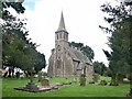
The Redundant Church of St Margaret, Wispington
The church of St Margaret holds furnishings from redundant churches and so is in itself redundant. I managed to hold my camera high and photograph its elaborately painted walls through the windows.
Image: © Dave Hitchborne
Taken: 24 Aug 2004
0.03 miles
2
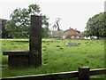
The memorial to the world ploughing championships held here in 1984
"Let peace till the fields" is the inscription
Image: © David Brown
Taken: 24 May 2024
0.03 miles
4
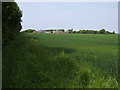
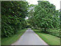
Looking up to
From track to Hall Farm looking up to Wispington
Image: © Shaun Ferguson
Taken: 21 May 2008
0.04 miles
5
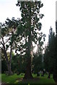
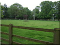
Wellingtonia tree in front of Wispington church
The church is dwarfed by the massive tree.
Image: © Chris
Taken: 19 Jun 2014
0.05 miles
6
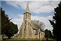
St.Margaret's church, Wispington
By John Bownas Atkinson of York in 1863, the font, pulpit and relief of St.Margaret were carved by the incumbent vicar Rev.Charles Pratt Terrot in 1863. Now redundant.
Image: © Richard Croft
Taken: 6 Apr 2007
0.05 miles
8
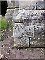
Cut Mark: Wispington, St Margaret's Church
Cut bench mark on a buttress at the SE angle. See http://www.bench-marks.org.uk/bm57519 for details.
Image: © Brian Westlake
Taken: 7 Mar 2013
0.05 miles
9
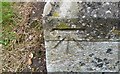
Ordnance Survey Cut Mark
This OS cut mark can be found on the SE face of St Margaret's Church. It marks a point 35.198m above mean sea level.
Image: © Adrian Dust
Taken: 23 Jul 2017
0.05 miles
10
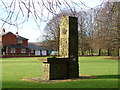
World Ploughing Contest Memorial
The event was held here in 1975. Plaques from various countries are bricked into the main pillar. The inscription round the model of the plough reads "Pax Arva Colat" - "Let Peace Till the Fields".
Image: © Ian Paterson
Taken: 29 Dec 2007
0.05 miles