IMAGES TAKEN NEAR TO
Horncastle Road, HORNCASTLE, LN9 5QP
Introduction
This page details the photographs taken nearby to Horncastle Road, LN9 5QP by members of the Geograph project.
The Geograph project started in 2005 with the aim of publishing, organising and preserving representative images for every square kilometre of Great Britain, Ireland and the Isle of Man.

There are currently over 7.5m images from over14,400 individuals and you can help contribute to the project by visiting https://www.geograph.org.uk
Image Map
Images are licensed for reuse under creativecommons.org/licenses/by-sa/2.0
Notes
- Clicking on the map will re-center to the selected point.
- The higher the marker number, the further away the image location is from the centre of the postcode.
Image Listing (12 Images Found)
Images are licensed for reuse under creativecommons.org/licenses/by-sa/2.0
Image
Details
Distance
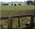
2
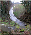
Beck near Sands Farm
Beck running to down to the River Bain near Sands Farm, Hemingby. In the foreground are the coping stones of a brick-built culvert taking the water under the road.
Image: © Kate Nicol
Taken: 5 Feb 2010
0.06 miles
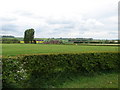
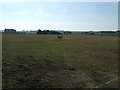
5
Sands Farm
Looking from Sands Farm along public footpath. The houses of New End can be seen on the horizon.
Image: © Kate Nicol
Taken: 5 Feb 2010
0.09 miles
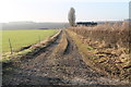
7
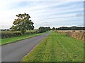
Hemingsby Lane near Sands Farm
The very wide verges suggest that this might at one stage have been a drove road.
Image: © Oliver Dixon
Taken: 7 Oct 2012
0.10 miles
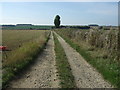
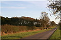
8
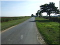
Minor road towards Horncastle
Heading south east.
Image: © JThomas
Taken: 28 Sep 2013
0.11 miles
10
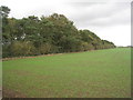
Mixed plantation
Woodland is scarce in this part of the Lincolnshire Wolds.
Image: © Jonathan Thacker
Taken: 13 Oct 2011
0.22 miles