IMAGES TAKEN NEAR TO
Hemingby, HORNCASTLE, LN9 5QF
Introduction
This page details the photographs taken nearby to LN9 5QF by members of the Geograph project.
The Geograph project started in 2005 with the aim of publishing, organising and preserving representative images for every square kilometre of Great Britain, Ireland and the Isle of Man.

There are currently over 7.5m images from over14,400 individuals and you can help contribute to the project by visiting https://www.geograph.org.uk
Image Map
Images are licensed for reuse under creativecommons.org/licenses/by-sa/2.0
Notes
- Clicking on the map will re-center to the selected point.
- The higher the marker number, the further away the image location is from the centre of the postcode.
Image Listing (36 Images Found)
Images are licensed for reuse under creativecommons.org/licenses/by-sa/2.0
Image
Details
Distance
1
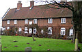
Hemingby Almshouses
Row of almshouses seen to the N boundary of the churchyard. There is an inscription which reads 'This Hospital and School were erected in the year 1727 by Jane Dymoke'
Jane Dymoke established a yearly allowance for four poor widows of Lincolnshire to live in the hospital. There was a 145 acre farm associated with the hospital for revenue purposes. The four almswomen received a weekly allowance of two shillings and thrupence, plus coal.
Jane Dymoke's charity also allowed for about four apprentices to be in training in Hemingby at any one time.
Reference: http://www.genuki.org.uk/big/eng/LIN/Hemingby/
Image: © Kate Nicol
Taken: 5 Feb 2010
0.01 miles
2
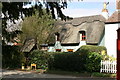
By-trees, Church Terrace, Hemingby
Image: © Jo and Steve Turner
Taken: 22 Mar 2019
0.01 miles
3
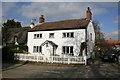
Corner House, Main Street, Hemingby
Image: © Jo and Steve Turner
Taken: 22 Mar 2019
0.02 miles
4
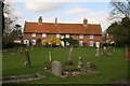
Almshouses, Main Street, Hemingby
Grade II Listed almshouses of 1727. Ashlar plaque above central doorway inscribed: "The Hospital and School were erected in the year 1747 by Jane Dymoke Widow of the Hon. Charles Dymoke of Scrivelsby Esq Champion of England and endowed by her will and a yearly salary to a School Master and Mistress for teaching all the poor children in the Parish of Hemingby to read write and work and with competent provision of clothing for six of the said children and for putting some of them Apprentices and also yearly allowance for four poor widows Inhabitants of the County of Lincolnshire is appointed in her will".
Image: © Jo and Steve Turner
Taken: 22 Mar 2019
0.02 miles
5
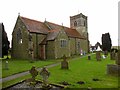
Hemingby Church
Saint Margaret, dating from the 14th century.
Image: © Ian Rob
Taken: 14 Dec 2014
0.03 miles
6
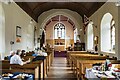
Interior, St Margaret's church, Hemingby
Looking east.
Image: © Julian P Guffogg
Taken: 9 Sep 2023
0.04 miles
7
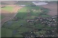
Hemingby and River Bain: aerial 2024
Top: Horncastle's flood alleviation reservoir: see Image
Image: © Chris
Taken: 7 Jan 2024
0.04 miles
8
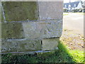
Ordnance Survey Cut Mark
This mark can be found on the wall of St Margaret's Church in Hemingby. The benchmark height is recorded as being 48.07 metres above sea level.
For more detail see : https://www.bench-marks.org.uk/bm31599
Image: © Peter Wood
Taken: 25 Feb 2019
0.04 miles
9
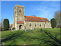
The Church of St Margaret at Hemingby
Viewed from the south.
Image: © Peter Wood
Taken: 25 Feb 2019
0.04 miles
10
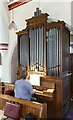
Organ, St Margaret's church, Hemingby
A Casson positive single manual organ with 10 stops. It came from an unknown private residence.
Image: © Julian P Guffogg
Taken: 9 Sep 2023
0.04 miles