IMAGES TAKEN NEAR TO
Midthorpe, HORNCASTLE, LN9 5PZ
Introduction
This page details the photographs taken nearby to Midthorpe, LN9 5PZ by members of the Geograph project.
The Geograph project started in 2005 with the aim of publishing, organising and preserving representative images for every square kilometre of Great Britain, Ireland and the Isle of Man.

There are currently over 7.5m images from over14,400 individuals and you can help contribute to the project by visiting https://www.geograph.org.uk
Image Map
Images are licensed for reuse under creativecommons.org/licenses/by-sa/2.0
Notes
- Clicking on the map will re-center to the selected point.
- The higher the marker number, the further away the image location is from the centre of the postcode.
Image Listing (5 Images Found)
Images are licensed for reuse under creativecommons.org/licenses/by-sa/2.0
Image
Details
Distance
1
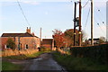
Mid Thorpe and the start of the path to Far Thorpe
Image: © Chris
Taken: 12 Nov 2013
0.02 miles
3
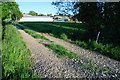
Ford on the West Ashby Beck, Midthorpe
This ford is found at Valley Farm off Watery Lane, Midthorpe.
Image: © John Walton
Taken: 23 May 2010
0.11 miles
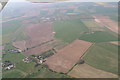
5
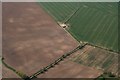
Parch marks in field by West Ashby Beck east of Midthorpe: aerial 2019
Image: © Simon Tomson
Taken: 20 Apr 2019
0.25 miles