IMAGES TAKEN NEAR TO
Chapel Lane, HORNCASTLE, LN9 5NQ
Introduction
This page details the photographs taken nearby to Chapel Lane, LN9 5NQ by members of the Geograph project.
The Geograph project started in 2005 with the aim of publishing, organising and preserving representative images for every square kilometre of Great Britain, Ireland and the Isle of Man.

There are currently over 7.5m images from over14,400 individuals and you can help contribute to the project by visiting https://www.geograph.org.uk
Image Map
Images are licensed for reuse under creativecommons.org/licenses/by-sa/2.0
Notes
- Clicking on the map will re-center to the selected point.
- The higher the marker number, the further away the image location is from the centre of the postcode.
Image Listing (59 Images Found)
Images are licensed for reuse under creativecommons.org/licenses/by-sa/2.0
Image
Details
Distance
1
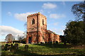
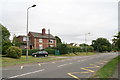
St.Swithin's church, Baumber, Lincs.
An unusual and fascinating church, effectively a medieval church encased in a Georgian red brick shell in 1758. Inside, there's a Norman west door and Early English nave.
Image: © Richard Croft
Taken: 26 Jan 2006
0.05 miles
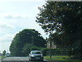
2
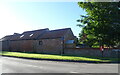
Farm buildings on West Lane, Baumber
Showing position of Postbox No. LN9 309.
See Image] for postbox.
Image: © JThomas
Taken: 11 Jul 2020
0.06 miles
3
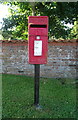
Elizabeth II postbox on West Lane, Baumber
Image: © JThomas
Taken: 11 Jul 2020
0.07 miles
4
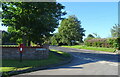
West Lane, Baumber
Junction with the A158.
Showing position of Postbox No. LN9 309.
See Image] for postbox.
Image: © JThomas
Taken: 11 Jul 2020
0.08 miles
6
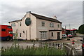
Dead Lion: the former Red Lion pub
Another closed pub, in the village of Baumber.
Image: © Chris
Taken: 21 Aug 2013
0.10 miles
7
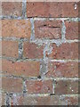
Cut Mark: Baumber, The Old Vicarage
Cut mark on the wall of the property at the road junction. See http://www.geograph.org.uk/photo/3379344 for a wider view and http://www.bench-marks.org.uk/bm34113 for details.
Image: © Brian Westlake
Taken: 13 Sep 2012
0.10 miles
8
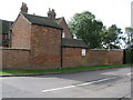
Baumber, The Old Vicarage
Walls and outbuildings at the road junction. A cut bench mark is close to the join of the outbuilding to the left-hand wall. See http://www.geograph.org.uk/photo/3379338 for a close-up.
Image: © Brian Westlake
Taken: 13 Sep 2012
0.10 miles
9
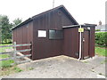
Baumber Telephone Exchange (2)
This dark wooden TE off the A158 road, is recognisable by the square white BT warning notice on the left of the building. This TE has the numbering range (01507) 578xxx, the (01507) referring to the Alford, Horncastle and Louth group of eighteen TEs, and its postcode is LN9 5NE.
Image: © David Hillas
Taken: 17 Jul 2019
0.10 miles