IMAGES TAKEN NEAR TO
Baumber, HORNCASTLE, LN9 5NE
Introduction
This page details the photographs taken nearby to LN9 5NE by members of the Geograph project.
The Geograph project started in 2005 with the aim of publishing, organising and preserving representative images for every square kilometre of Great Britain, Ireland and the Isle of Man.

There are currently over 7.5m images from over14,400 individuals and you can help contribute to the project by visiting https://www.geograph.org.uk
Image Map
Images are licensed for reuse under creativecommons.org/licenses/by-sa/2.0
Notes
- Clicking on the map will re-center to the selected point.
- The higher the marker number, the further away the image location is from the centre of the postcode.
Image Listing (6 Images Found)
Images are licensed for reuse under creativecommons.org/licenses/by-sa/2.0
Image
Details
Distance
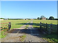
1
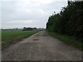
Track to Stockborough Farm, Baumber
Image: © J.Hannan-Briggs
Taken: 16 Oct 2011
0.13 miles
2
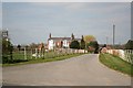
Limes Cottage
Farm cottage and buildings at The Limes
Image: © Richard Croft
Taken: 6 Apr 2007
0.20 miles
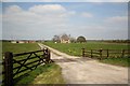
3
Cattle and felled tree at Baumber Park Farm
Image: © Oliver Dixon
Taken: 10 Jun 2012
0.22 miles
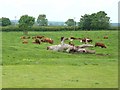
5
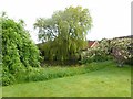
Pond at Baumber Park Farm
Attractive pond at the bottom of the garden.
Image: © Oliver Dixon
Taken: 10 Jun 2012
0.24 miles