IMAGES TAKEN NEAR TO
Louth Road, HORNCASTLE, LN9 5LJ
Introduction
This page details the photographs taken nearby to Louth Road, LN9 5LJ by members of the Geograph project.
The Geograph project started in 2005 with the aim of publishing, organising and preserving representative images for every square kilometre of Great Britain, Ireland and the Isle of Man.

There are currently over 7.5m images from over14,400 individuals and you can help contribute to the project by visiting https://www.geograph.org.uk
Image Map
Images are licensed for reuse under creativecommons.org/licenses/by-sa/2.0
Notes
- Clicking on the map will re-center to the selected point.
- The higher the marker number, the further away the image location is from the centre of the postcode.
Image Listing (16 Images Found)
Images are licensed for reuse under creativecommons.org/licenses/by-sa/2.0
Image
Details
Distance
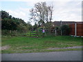
1
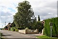
Low Toynton Road
This is a quiet suburban street on the northern edge of Horncastle.
Image: © Tony Atkin
Taken: 7 Sep 2006
0.15 miles
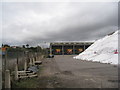
2
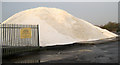
Salt Mountain
Heap of salt for road treatment at the Council depot on Hemingby Lane.
Image: © Kate Nicol
Taken: 5 Feb 2010
0.17 miles
3
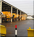
Council Highways depot
Fleet of gritting lorries in their stable.
Image: © Kate Nicol
Taken: 5 Feb 2010
0.17 miles
4
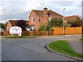
Oak Tree Meadow
It would be funny, if it were not so sad, to see how attempts are made to soften the encroachment of the countryside by modern housing, by giving the developments twee rustic-sounding names.
Image: © Oliver Dixon
Taken: 7 Oct 2012
0.19 miles
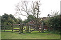
6
Approaching Horncastle
Residential perimeter of Horncastle from the Viking Way on Low Toynton Road
Image: © Richard Croft
Taken: 16 Feb 2008
0.19 miles
7

Council Highways Depot, Hemingsby Lane, Horncastle
Mountains of road salt under wraps waiting for the onset of winter.
Image: © Oliver Dixon
Taken: 7 Oct 2012
0.21 miles
8
The Viking Way entering Horncastle
The Way skirts around the east side of the town before heading for the centre.
Image: © Tim Heaton
Taken: 13 Sep 2011
0.21 miles
9
Ready for the winter
A heap of salt on the right and gritters prepared.
Image: © Jonathan Thacker
Taken: 13 Oct 2011
0.21 miles
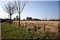
10
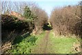
The Viking Way
The Viking Way long distance footpath between Bowl Alley Lane and Low Toynton Road - the parish boundary between Horncastle and Low Toynton
Image: © Richard Croft
Taken: 16 Feb 2008
0.22 miles