IMAGES TAKEN NEAR TO
Ashwood Close, HORNCASTLE, LN9 5HA
Introduction
This page details the photographs taken nearby to Ashwood Close, LN9 5HA by members of the Geograph project.
The Geograph project started in 2005 with the aim of publishing, organising and preserving representative images for every square kilometre of Great Britain, Ireland and the Isle of Man.

There are currently over 7.5m images from over14,400 individuals and you can help contribute to the project by visiting https://www.geograph.org.uk
Image Map
Images are licensed for reuse under creativecommons.org/licenses/by-sa/2.0
Notes
- Clicking on the map will re-center to the selected point.
- The higher the marker number, the further away the image location is from the centre of the postcode.
Image Listing (425 Images Found)
Images are licensed for reuse under creativecommons.org/licenses/by-sa/2.0
Image
Details
Distance
1
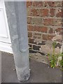
Cut Mark: Horncastle, 29 Prospect Street
The cuts of this bench mark have been filled with cement. See http://www.geograph.org.uk/photo/5479577 for a wider view and http://www.bench-marks.org.uk/bm33058 for details.
Image: © Brian Westlake
Taken: 28 Jul 2017
0.04 miles
2
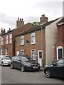
Horncastle, 29 Prospect Street
The house carries a damaged cut bench mark on the angle right of the door. See http://www.geograph.org.uk/photo/5479571 for a close-up and http://www.bench-marks.org.uk/bm33058 for details.
Image: © Brian Westlake
Taken: 28 Jul 2017
0.04 miles
3
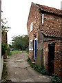
Alleyway, West Street, Horncastle
A close-up, without intruding, of a building with corbelling on the corner of its walls. This building work is useful where horses and carts would be turning in and out of a courtyard and into a narrow alleyway.
Corbelling - Where a wall projects outwards in steps without compromising the integrity of the structure.
Image: © Dave Hitchborne
Taken: 5 Nov 2007
0.09 miles
4
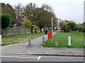
Path at Prospect Street, Horncastle
This pathway leads across the River Bain to Tesco's car park, via a children's play area.
Image: © Dave Hitchborne
Taken: 5 Nov 2007
0.09 miles
5
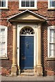
Georgian Doorway
Grand entrance to 2 West Street
Image: © Richard Croft
Taken: 28 Mar 2007
0.09 miles
6
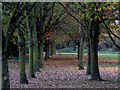
Path at Prospect Street, Horncastle
Just off the pathway from Prospect Street to Tesco's is this small avenue of trees.
Image: © Dave Hitchborne
Taken: 5 Nov 2007
0.09 miles
7
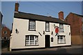
The Crown
One of Horncastle's numerous historic inns
Image: © Richard Croft
Taken: 28 Mar 2007
0.10 miles
8
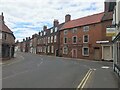
West Street, Horncastle
A street of eighteenth and nineteenth century houses, though some may be simply facades for older buildings.
Image: © Jonathan Thacker
Taken: 17 Jun 2010
0.10 miles
9
The (ex) Fighting Cocks
From 100 metres away it was obvious that this pub was no longer in business. However I thought that maybe the sign was still there. Also no!
Checking on Google Street View it looks like the pub was still open in 2018 as there's a chalk board by the door with opening times in Sept that year, though the curtains are closed. The next time the Google car passed by in 2011 it was definitely closed. The sign went well before that, disappearing between April 2011 and November 2015.
The building is Grade II listed with a date of "Late C18, mid C19"
List Entry Number:1251998 https://historicengland.org.uk/listing/the-list/list-entry/1251998?section=official-list-entry
Image: © David Lally
Taken: 24 Jun 2023
0.10 miles
10
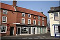
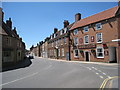
Prospect Street
Georgian building dated 1810 and the entrance to Grundy's Yard at the junction of Prospect Street, West Street and Bridge Street
Image: © Richard Croft
Taken: 28 Mar 2007
0.10 miles