IMAGES TAKEN NEAR TO
Maple Close, HORNCASTLE, LN9 5EY
Introduction
This page details the photographs taken nearby to Maple Close, LN9 5EY by members of the Geograph project.
The Geograph project started in 2005 with the aim of publishing, organising and preserving representative images for every square kilometre of Great Britain, Ireland and the Isle of Man.

There are currently over 7.5m images from over14,400 individuals and you can help contribute to the project by visiting https://www.geograph.org.uk
Image Map
Images are licensed for reuse under creativecommons.org/licenses/by-sa/2.0
Notes
- Clicking on the map will re-center to the selected point.
- The higher the marker number, the further away the image location is from the centre of the postcode.
Image Listing (7 Images Found)
Images are licensed for reuse under creativecommons.org/licenses/by-sa/2.0
Image
Details
Distance
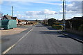
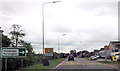
4
Accommodation Road
It was a few decades after the houses on the right of this picture were built before Horncastle grew to fill the gap between them and the rest of the town.
Image: © Jonathan Thacker
Taken: 13 Oct 2011
0.18 miles
7
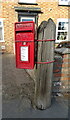
Elizabeth II postbox on Lincoln Road, Horncastle
Postbox No. LN9 68.
See Image] for context.
Image: © JThomas
Taken: 17 Jul 2020
0.25 miles