IMAGES TAKEN NEAR TO
Lancaster Avenue, HORNCASTLE, LN9 5EW
Introduction
This page details the photographs taken nearby to Lancaster Avenue, LN9 5EW by members of the Geograph project.
The Geograph project started in 2005 with the aim of publishing, organising and preserving representative images for every square kilometre of Great Britain, Ireland and the Isle of Man.

There are currently over 7.5m images from over14,400 individuals and you can help contribute to the project by visiting https://www.geograph.org.uk
Image Map
Images are licensed for reuse under creativecommons.org/licenses/by-sa/2.0
Notes
- Clicking on the map will re-center to the selected point.
- The higher the marker number, the further away the image location is from the centre of the postcode.
Image Listing (41 Images Found)
Images are licensed for reuse under creativecommons.org/licenses/by-sa/2.0
Image
Details
Distance
1
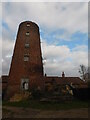
Holmes's Mill, Spilsbury Road
I come from a family of millers. This was our mill. Long since fallen out of our hands way before my time, and sadly derelict, I took a trip to visit it in 2018. Would love to see it restored one day.
Image: © Bryn Holmes
Taken: 24 Nov 2018
0.09 miles
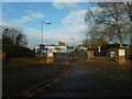
2
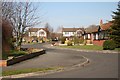
Tudor Park
Housing development in Horncastle
Image: © Richard Croft
Taken: 16 Feb 2008
0.15 miles
3
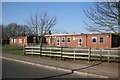
St.Lawrence School
For pupils with special needs http://www.st-lawrence-special.lincs.sch.uk/
Image: © Richard Croft
Taken: 16 Feb 2008
0.15 miles
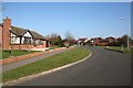
4
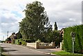
Low Toynton Road
This is a quiet suburban street on the northern edge of Horncastle.
Image: © Tony Atkin
Taken: 7 Sep 2006
0.16 miles
5
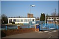
Horncastle Community Primary School
Primary School on Bowl Alley Lane
Image: © Richard Croft
Taken: 16 Feb 2008
0.17 miles
6
Horncastle Primary School, Bowl Alley Lane
Image: © Bryn Holmes
Taken: 24 Nov 2018
0.17 miles
7
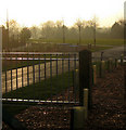
Bain Valley Park
This new community park is due to open in Spring 2010. The District Council was awarded £850,000 by East Midlands Development Agency to transform this disused wasteland on the outskirts of Horncastle into parkland. The name was chosen by residents through a ballot.
The development includes a grassed open space for community events edged with a seating wall, landscaping, viewing platforms, footpaths, cycle ways and disabled car parking facilities.
The park will also provide a link between Hemingby Lane and the new Bell's Yard development off the Louth Road.
Image: © Kate Nicol
Taken: 5 Feb 2010
0.18 miles
8
Tudor Park
Housing development at Horncastle
Image: © Richard Croft
Taken: 16 Feb 2008
0.18 miles
9
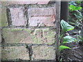
Ordnance Survey Cut Mark
This mark can be found on the wall of a house in Bowl Alley Lane.
For more detail see : http://www.bench-marks.org.uk/bm43654
Image: © Peter Wood
Taken: 27 Jun 2012
0.19 miles
10

Salt Mountain
Heap of salt for road treatment at the Council depot on Hemingby Lane.
Image: © Kate Nicol
Taken: 5 Feb 2010
0.19 miles