IMAGES TAKEN NEAR TO
Bowl Alley Lane, HORNCASTLE, LN9 5EQ
Introduction
This page details the photographs taken nearby to Bowl Alley Lane, LN9 5EQ by members of the Geograph project.
The Geograph project started in 2005 with the aim of publishing, organising and preserving representative images for every square kilometre of Great Britain, Ireland and the Isle of Man.

There are currently over 7.5m images from over14,400 individuals and you can help contribute to the project by visiting https://www.geograph.org.uk
Image Map
Images are licensed for reuse under creativecommons.org/licenses/by-sa/2.0
Notes
- Clicking on the map will re-center to the selected point.
- The higher the marker number, the further away the image location is from the centre of the postcode.
Image Listing (284 Images Found)
Images are licensed for reuse under creativecommons.org/licenses/by-sa/2.0
Image
Details
Distance
1
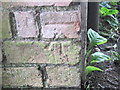
Ordnance Survey Cut Mark
This mark can be found on the wall of a house in Bowl Alley Lane.
For more detail see : http://www.bench-marks.org.uk/bm43654
Image: © Peter Wood
Taken: 27 Jun 2012
0.01 miles
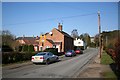
2
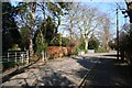
Bowl Alley Lane
Residential area of Horncastle on the Viking Way
Image: © Richard Croft
Taken: 16 Feb 2008
0.02 miles
3
Horncastle Primary School, Bowl Alley Lane
Image: © Bryn Holmes
Taken: 24 Nov 2018
0.03 miles
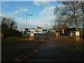
4
Horncastle Community Primary School
Primary School on Bowl Alley Lane
Image: © Richard Croft
Taken: 16 Feb 2008
0.04 miles
5
Stanhope Road
Residential area of Horncastle
Image: © Richard Croft
Taken: 16 Feb 2008
0.08 miles
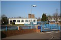
6

St.Lawrence School
For pupils with special needs http://www.st-lawrence-special.lincs.sch.uk/
Image: © Richard Croft
Taken: 16 Feb 2008
0.09 miles
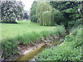
7

River Waring
The River Waring seen from Stanhope Road
Image: © Richard Croft
Taken: 16 Feb 2008
0.10 miles
10
Banks Road, Horncastle
Looking from the footbridge over the River Waring to Banks Road, which runs parallel with the river. The road opposite is Linden Road. On the waste ground was once Eric E Woods, Motor Engineers. My wife took her car there for repair and never got it back or any recompence for the loss. The garage folded and apparently the car was scrapped.
Image: © Dave Hitchborne
Taken: 18 Jul 2009
0.11 miles