IMAGES TAKEN NEAR TO
Stanhope Terrace, HORNCASTLE, LN9 5EG
Introduction
This page details the photographs taken nearby to Stanhope Terrace, LN9 5EG by members of the Geograph project.
The Geograph project started in 2005 with the aim of publishing, organising and preserving representative images for every square kilometre of Great Britain, Ireland and the Isle of Man.

There are currently over 7.5m images from over14,400 individuals and you can help contribute to the project by visiting https://www.geograph.org.uk
Image Map
Images are licensed for reuse under creativecommons.org/licenses/by-sa/2.0
Notes
- Clicking on the map will re-center to the selected point.
- The higher the marker number, the further away the image location is from the centre of the postcode.
Image Listing (526 Images Found)
Images are licensed for reuse under creativecommons.org/licenses/by-sa/2.0
Image
Details
Distance
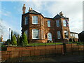
2
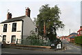
Stanhope Road
Residential area of Horncastle
Image: © Richard Croft
Taken: 16 Feb 2008
0.04 miles
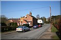
3
Banks Road, Horncastle
Looking from the footbridge over the River Waring to Banks Road, which runs parallel with the river. The road opposite is Linden Road. On the waste ground was once Eric E Woods, Motor Engineers. My wife took her car there for repair and never got it back or any recompence for the loss. The garage folded and apparently the car was scrapped.
Image: © Dave Hitchborne
Taken: 18 Jul 2009
0.05 miles
4
Bowl Alley Lane
Residential area of Horncastle on the Viking Way
Image: © Richard Croft
Taken: 16 Feb 2008
0.06 miles
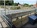
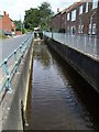
5
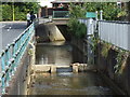
River Waring, Horncastle
A small weir and a water level monitor in the concrete confines of the river. The road running parallel is Banks Road and the road ahead is Stanhope Road.
Image: © Dave Hitchborne
Taken: 18 Jul 2009
0.07 miles
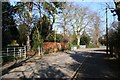
6
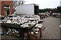
Clare Road
A tiny fraction of the stock in the labyrinth of rooms, yards and buildings behind an unassuming antique shop front on North Street http://www.geograph.org.uk/photo/76803
Image: © Richard Croft
Taken: 30 Mar 2007
0.07 miles
7
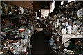
Aladdin's cave
A tiny fraction of the stock in the labyrinth of rooms, yards and buildings behind an unassuming antique shop front on North Street http://www.geograph.org.uk/photo/76803
Image: © Richard Croft
Taken: 30 Mar 2007
0.07 miles
9
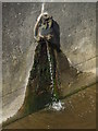
River Waring, Horncastle
A Ham Baker cast iron flap valve, which is leaking a little.
Image: © Dave Hitchborne
Taken: 18 Jul 2009
0.07 miles
10
River Waring, Horncastle
Normally a placid river, but capable of flooding the town, which it has done on occasions.
Image: © Dave Hitchborne
Taken: 18 Jul 2009
0.07 miles