IMAGES TAKEN NEAR TO
Stanhope Road, HORNCASTLE, LN9 5DG
Introduction
This page details the photographs taken nearby to Stanhope Road, LN9 5DG by members of the Geograph project.
The Geograph project started in 2005 with the aim of publishing, organising and preserving representative images for every square kilometre of Great Britain, Ireland and the Isle of Man.

There are currently over 7.5m images from over14,400 individuals and you can help contribute to the project by visiting https://www.geograph.org.uk
Image Map
Images are licensed for reuse under creativecommons.org/licenses/by-sa/2.0
Notes
- Clicking on the map will re-center to the selected point.
- The higher the marker number, the further away the image location is from the centre of the postcode.
Image Listing (362 Images Found)
Images are licensed for reuse under creativecommons.org/licenses/by-sa/2.0
Image
Details
Distance
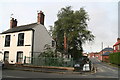
1
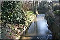
River Waring
The River Waring seen from Stanhope Road
Image: © Richard Croft
Taken: 16 Feb 2008
0.03 miles
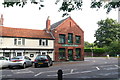
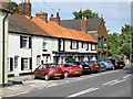
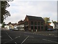
3
Stanhope Road
Residential area of Horncastle
Image: © Richard Croft
Taken: 16 Feb 2008
0.04 miles
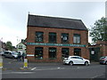
4
Antique shop on the corner of East Street and Stanhope Road
Image: © Chris
Taken: 13 Sep 2013
0.04 miles
7
East Street, Horncastle
Nos.71-75 is Magpies Restaurant, next door to which is Laurence Shaw Antiques. As well as selling antiques and bric a brac, they are also valuers and consultants and they do house clearances. Beyond Laurence Shaw's is Stanhope Road.
Image: © Dave Hitchborne
Taken: 18 Jul 2009
0.05 miles
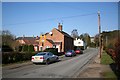
8
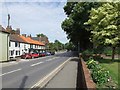
East Street, Horncastle
The A158 Skegness climbs steadily out of Horncastle until it reaches the B1195 to Spilsby and then there aren't many more hills after that as it slowly drops down to the sea. Improvements to the road include by-passes at Partney and Burgh le Marsh.
The tree is an Acer platanoides 'Drummondii'.
Image: © Dave Hitchborne
Taken: 18 Jul 2009
0.05 miles
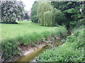
10
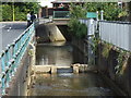
River Waring, Horncastle
A small weir and a water level monitor in the concrete confines of the river. The road running parallel is Banks Road and the road ahead is Stanhope Road.
Image: © Dave Hitchborne
Taken: 18 Jul 2009
0.05 miles