IMAGES TAKEN NEAR TO
Stonewell Row, HORNCASTLE, LN9 5DD
Introduction
This page details the photographs taken nearby to Stonewell Row, LN9 5DD by members of the Geograph project.
The Geograph project started in 2005 with the aim of publishing, organising and preserving representative images for every square kilometre of Great Britain, Ireland and the Isle of Man.

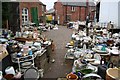
There are currently over 7.5m images from over14,400 individuals and you can help contribute to the project by visiting https://www.geograph.org.uk
Image Map
Images are licensed for reuse under creativecommons.org/licenses/by-sa/2.0
Notes
- Clicking on the map will re-center to the selected point.
- The higher the marker number, the further away the image location is from the centre of the postcode.
Image Listing (688 Images Found)
Images are licensed for reuse under creativecommons.org/licenses/by-sa/2.0
Image
Details
Distance
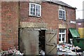
1
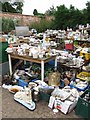
Clare Road
A tiny fraction of the stock in the labyrinth of rooms, yards and buildings behind an unassuming antique shop front on North Street http://www.geograph.org.uk/photo/76803
Image: © Richard Croft
Taken: 30 Mar 2007
0.02 miles
2
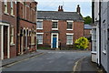
Banks Street, Horncastle
The houses really are not all standing at the same angle!
Image: © David Martin
Taken: 18 Jul 2019
0.03 miles
3

River Waring, Horncastle
The signature of the Lesser-Spotted Moron. The Greater-Spotted Moron's signature is the shopping trolley.
Fish are seen heading for some breadflake, which is steadily being carried up this almost level river, by the wind.
Image: © Dave Hitchborne
Taken: 18 Jul 2009
0.03 miles
4
Antique Shop, North Street, Horncastle
There must be something you want!
Image: © Dave Hitchborne
Taken: 2 Aug 2007
0.03 miles
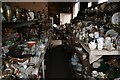
5
Outbuildings off North Street, Horncastle
Bric-a-brac wherever you look.
Image: © Dave Hitchborne
Taken: 2 Aug 2007
0.03 miles
6
Clare Road
Part of the labyrinth of rooms, yards and buildings behind an unassuming antique shop front on North Street http://www.geograph.org.uk/photo/76803 the whole of Clare Road is now full of the stock
Image: © Richard Croft
Taken: 30 Mar 2007
0.03 miles
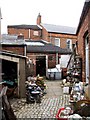
7
Aladdin's cave
A tiny fraction of the stock in the labyrinth of rooms, yards and buildings behind an unassuming antique shop front on North Street http://www.geograph.org.uk/photo/76803
Image: © Richard Croft
Taken: 30 Mar 2007
0.04 miles
8
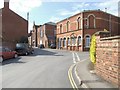
Banks Street, Horncastle
Banks Road becomes Banks Street at Linden Road and at the junction of Stonewell Row stands the Masonic Hall, Olive Union (Old) Lodge No:858 - est 1831 http://www.geograph.org.uk/photo/1709927. A few yards further on is North Street and the High Street shops at the Bull Ring. Banks Street takes its name from Sir Joseph Banks the naturalist and botanist who lived in Revesby Abbey. To the left, but out of shot, runs the River Waring.
Image: © Dave Hitchborne
Taken: 18 Jul 2009
0.04 miles
9
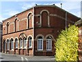
Masonic Hall, Banks Street/Stonewell Row, Horncastle
The Provincial Grand Lodge of Lincolnshire was established in 1792, although this Olive Union (Old) Lodge No:858, Horncastle, dates from 1831. 100 years passed before it was decided that some record be made of the Masonic events that preceded the 1892 Centenary Celebration and that probably wouldn't have happened then if someone's wife hadn't nagged them to do it.
Image: © Dave Hitchborne
Taken: 18 Jul 2009
0.04 miles
10

Clare Road
A tiny fraction of the stock in the labyrinth of rooms, yards and buildings behind an unassuming antique shop front on North Street http://www.geograph.org.uk/photo/76803
Image: © Richard Croft
Taken: 30 Mar 2007
0.04 miles