IMAGES TAKEN NEAR TO
The Spinney, HORNCASTLE, LN9 5BS
Introduction
This page details the photographs taken nearby to The Spinney, LN9 5BS by members of the Geograph project.
The Geograph project started in 2005 with the aim of publishing, organising and preserving representative images for every square kilometre of Great Britain, Ireland and the Isle of Man.

There are currently over 7.5m images from over14,400 individuals and you can help contribute to the project by visiting https://www.geograph.org.uk
Image Map
Images are licensed for reuse under creativecommons.org/licenses/by-sa/2.0
Notes
- Clicking on the map will re-center to the selected point.
- The higher the marker number, the further away the image location is from the centre of the postcode.
Image Listing (21 Images Found)
Images are licensed for reuse under creativecommons.org/licenses/by-sa/2.0
Image
Details
Distance
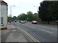
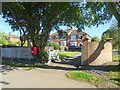
1

Houses on Lincoln Road, Horncastle
Showing position of Postbox No. LN9 68.
See Image] for postbox.
Image: © JThomas
Taken: 17 Jul 2020
0.03 miles
2
Elizabeth II postbox on Lincoln Road, Horncastle
Postbox No. LN9 68.
See Image] for context.
Image: © JThomas
Taken: 17 Jul 2020
0.03 miles
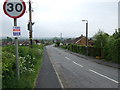
4

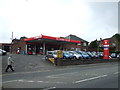
Garage and filling station, Lincoln Road (A158), Horncastle
Image: © David Smith
Taken: 19 Sep 2018
0.15 miles
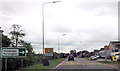
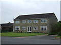
5
Houses on Langton Hill, Horncastle
Showing position of Postbox No. LN9 451.
See Image] for postbox.
Image: © JThomas
Taken: 17 Jul 2020
0.17 miles
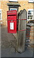
7
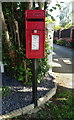
Elizabeth II postbox on Langton Hill, Horncastle
Postbox No. LN9 451.
See Image] for context.
Image: © JThomas
Taken: 17 Jul 2020
0.18 miles