IMAGES TAKEN NEAR TO
Donington Road, MARKET RASEN, LN8 6NJ
Introduction
This page details the photographs taken nearby to Donington Road, LN8 6NJ by members of the Geograph project.
The Geograph project started in 2005 with the aim of publishing, organising and preserving representative images for every square kilometre of Great Britain, Ireland and the Isle of Man.

There are currently over 7.5m images from over14,400 individuals and you can help contribute to the project by visiting https://www.geograph.org.uk
Image Map
Images are licensed for reuse under creativecommons.org/licenses/by-sa/2.0
Notes
- Clicking on the map will re-center to the selected point.
- The higher the marker number, the further away the image location is from the centre of the postcode.
Image Listing (35 Images Found)
Images are licensed for reuse under creativecommons.org/licenses/by-sa/2.0
Image
Details
Distance
1
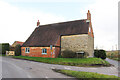
Corner Farm House
Grade II listed, late 18th century farmhouse, enlarged in the 19th & 20th centuries.
Image: © Richard Croft
Taken: 7 Mar 2023
0.01 miles
2
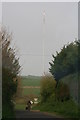
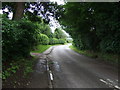
Leaving South Willingham on the Donnington Road
With the Belmont transmitter behind.
Image: © Chris
Taken: 20 Apr 2014
0.03 miles
3
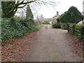
Church Lane in South Willingham
Looking north-eastward.
Image: © Peter Wood
Taken: 2 Mar 2019
0.04 miles
4
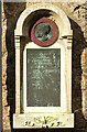
Matthew Ridley Corbet memorial
Memorial to artist Matthew Ridley Corbet ARA https://en.wikisource.org/wiki/Dictionary_of_National_Biography,_1912_supplement/Corbet,_Matthew_Ridley on St. Martin's church. His father Rev. Andrew Corbet was Rector of St. Martin's church.
Matthew Ridley Corbet
Born here at the Rectory
XX May MDCCCL
Died at his home at
St. John's Wood, London
XXV June MDCCCCII
So Long a worshipper of nature
Hither came unwearied in that service
In Loving Memory
Image: © Richard Croft
Taken: 7 Mar 2023
0.06 miles

6
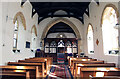
St. Martin's church nave
View east in the grade II* listed parish church, largely 14th century with a nave rebuild in 1848 and restoration 1885. The Perpendicular rood screen is much restored but interesting nonetheless.
Image: © Richard Croft
Taken: 7 Mar 2023
0.06 miles
7
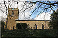
South Willingham Church
Church of St. Martin, South Willingham. Not easy to photograph due to bushes and trees.
Image: © David Wright
Taken: 14 Jun 2006
0.06 miles
9
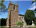
St. Martin's church
Grade II* listed parish church, largely 14th century with a nave rebuild in 1848 and restoration 1885.
Image: © Richard Croft
Taken: 7 Mar 2023
0.07 miles
10
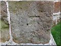
Ordnance Survey Cut Mark
This badly weathered mark can be found on the wall of St Martin's Church, South Willingham. The benchmark height is recorded as being 93.894 metres above sea level.
For more detail see : https://www.bench-marks.org.uk/bm105582
Image: © Peter Wood
Taken: 2 Mar 2019
0.07 miles