IMAGES TAKEN NEAR TO
Station Mews, MARKET RASEN, LN8 5RR
Introduction
This page details the photographs taken nearby to Station Mews, LN8 5RR by members of the Geograph project.
The Geograph project started in 2005 with the aim of publishing, organising and preserving representative images for every square kilometre of Great Britain, Ireland and the Isle of Man.

There are currently over 7.5m images from over14,400 individuals and you can help contribute to the project by visiting https://www.geograph.org.uk
Image Map
Images are licensed for reuse under creativecommons.org/licenses/by-sa/2.0
Notes
- Clicking on the map will re-center to the selected point.
- The higher the marker number, the further away the image location is from the centre of the postcode.
Image Listing (16 Images Found)
Images are licensed for reuse under creativecommons.org/licenses/by-sa/2.0
Image
Details
Distance
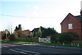
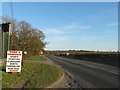
1
Once Wragby Railway Station
Shut to freight in 1960 and passenger services as long ago as 1951. The station house is nicly restored with some period signs from the time.
Image: © roger geach
Taken: 27 Sep 2011
0.03 miles
2
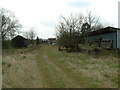
Wragby Station Yard
The long-disused Station Yard at Wragby
Image: © David Prestidge
Taken: 10 Apr 2004
0.03 miles
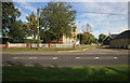
5
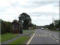
Bus shelter, Horncastle Road, Wragby
This stop serves the housing estate to the left
Image: © David Smith
Taken: 19 Sep 2018
0.09 miles
6
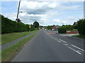
Horncastle Road (A158), Wragby
Heading south east.
Image: © JThomas
Taken: 15 Jun 2015
0.15 miles
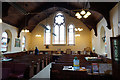
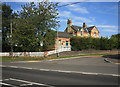
10
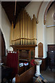
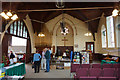
Wragby Methodist Church
The church organ is a war memorial to the men of the church.
Image: © Ian S
Taken: 12 May 2018
0.21 miles