IMAGES TAKEN NEAR TO
Kilmister Court, MARKET RASEN, LN8 5AF
Introduction
This page details the photographs taken nearby to Kilmister Court, LN8 5AF by members of the Geograph project.
The Geograph project started in 2005 with the aim of publishing, organising and preserving representative images for every square kilometre of Great Britain, Ireland and the Isle of Man.

There are currently over 7.5m images from over14,400 individuals and you can help contribute to the project by visiting https://www.geograph.org.uk
Image Map
Images are licensed for reuse under creativecommons.org/licenses/by-sa/2.0
Notes
- Clicking on the map will re-center to the selected point.
- The higher the marker number, the further away the image location is from the centre of the postcode.
Image Listing (115 Images Found)
Images are licensed for reuse under creativecommons.org/licenses/by-sa/2.0
Image
Details
Distance
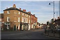
1
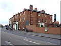
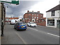
Turnor Arms, Wragby
Tom Woods beers prominently displayed on the splendid signs.
Image: © al partington
Taken: 5 Mar 2008
0.04 miles
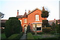
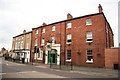
4
Cottages on the B1202 northwards out of Wragby
Image: © Chris
Taken: 2 Mar 2013
0.05 miles
6
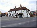
The Adam and Eve, Wragby
Still sporting the Mansfield brewery colours.
Image: © al partington
Taken: 5 Mar 2008
0.05 miles
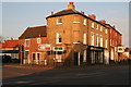
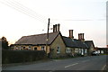
8
Turnor Arms Hotel
Early 19th century inn with the carriage arch now forming the main entrance
Image: © Richard Croft
Taken: 15 Sep 2008
0.06 miles
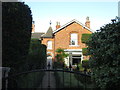
10
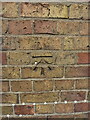
OS benchmark - Wragby, Manor Farm House
An OS cutmark on the south-facing wall of an old house at the crossroads, which is shown on older maps at 88.5ft above Liverpool datum, but is now recorded by the OS at 26.768m Ordnance Datum Newlyn.
Image: © Richard Law
Taken: 23 Jul 2022
0.06 miles