IMAGES TAKEN NEAR TO
Walesby Moor, MARKET RASEN, LN8 3TQ
Introduction
This page details the photographs taken nearby to LN8 3TQ by members of the Geograph project.
The Geograph project started in 2005 with the aim of publishing, organising and preserving representative images for every square kilometre of Great Britain, Ireland and the Isle of Man.

There are currently over 7.5m images from over14,400 individuals and you can help contribute to the project by visiting https://www.geograph.org.uk
Image Map
Images are licensed for reuse under creativecommons.org/licenses/by-sa/2.0
Notes
- Clicking on the map will re-center to the selected point.
- The higher the marker number, the further away the image location is from the centre of the postcode.
Image Listing (6 Images Found)
Images are licensed for reuse under creativecommons.org/licenses/by-sa/2.0
Image
Details
Distance
1
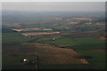
Otby Moor and the western escarpment of the Lincolnshire Wolds: aerial 2015
Image: © Chris
Taken: 5 Apr 2015
0.04 miles
2
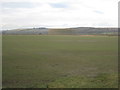
View across Otby Moor towards the Lincolnshire Wolds
Image: © Jonathan Thacker
Taken: 15 Feb 2013
0.17 miles
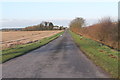
4

Bridleway Road
This well surfaced farm road is also a bridleway.
Image: © Michael Patterson
Taken: 9 Oct 2006
0.20 miles
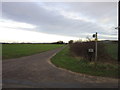
6
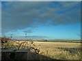
View over Otby Moor from Moor Road
The white dot centre right looks like a radar tower?
Image: © Steve Fareham
Taken: 30 Dec 2012
0.22 miles