IMAGES TAKEN NEAR TO
Caistor Road, MARKET RASEN, LN8 3SY
Introduction
This page details the photographs taken nearby to Caistor Road, LN8 3SY by members of the Geograph project.
The Geograph project started in 2005 with the aim of publishing, organising and preserving representative images for every square kilometre of Great Britain, Ireland and the Isle of Man.

There are currently over 7.5m images from over14,400 individuals and you can help contribute to the project by visiting https://www.geograph.org.uk
Image Map
Images are licensed for reuse under creativecommons.org/licenses/by-sa/2.0
Notes
- Clicking on the map will re-center to the selected point.
- The higher the marker number, the further away the image location is from the centre of the postcode.
Image Listing (8 Images Found)
Images are licensed for reuse under creativecommons.org/licenses/by-sa/2.0
Image
Details
Distance
5
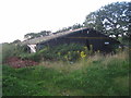
Abandoned chicken shed near Usselby
At least, that is what it appears to be.
Image: © Jonathan Thacker
Taken: 22 Aug 2012
0.23 miles
7
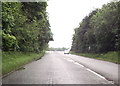
A46 passing Usselby plantation to A1103 junction
Image: © John Firth
Taken: 15 Jun 2012
0.24 miles