IMAGES TAKEN NEAR TO
Heron Way, MARKET RASEN, LN8 3RB
Introduction
This page details the photographs taken nearby to Heron Way, LN8 3RB by members of the Geograph project.
The Geograph project started in 2005 with the aim of publishing, organising and preserving representative images for every square kilometre of Great Britain, Ireland and the Isle of Man.

There are currently over 7.5m images from over14,400 individuals and you can help contribute to the project by visiting https://www.geograph.org.uk
Image Map (Loading...)


Getting Data...Please wait
Leaflet Map data © OpenStreetMap
Images are licensed for reuse under creativecommons.org/licenses/by-sa/2.0
Notes
- Clicking on the map will re-center to the selected point.
- The higher the marker number, the further away the image location is from the centre of the postcode.
Image Listing (13 Images Found)
Images are licensed for reuse under creativecommons.org/licenses/by-sa/2.0
Image
Details
Distance

2
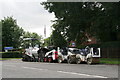
Specialist Resurfacing Limited's equipment
On the roadside by the De Aston School on a Sunday morning. Presumably stored for the weekend.
Image: © Chris
Taken: 18 Aug 2013
0.13 miles
3
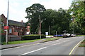
De Aston School and road resurfacing equipment
Specialist Resurfacing Limited seems to have parked up its equipment for the weekend.
Image: © Chris
Taken: 18 Aug 2013
0.14 miles
4
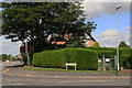
Anglian Way - Anglian Water
The Anglian Water and its facility seem to have given their name to the street.
Image: © Chris
Taken: 18 Aug 2013
0.14 miles
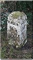
5
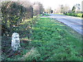
Rasen 3/4 Miles
Old milepost on the A.631 near to Market Rasen, Lincolnshire. For close up view see http://www.geograph.org.uk/photo/2733017
Image: © Keith Evans
Taken: 13 Dec 2011
0.15 miles
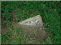
6
Old Milepost
Old milepost on the A.631 near to Market Rasen, Lincolnshire. For overall view see http://www.geograph.org.uk/photo/2733013
Image: © Keith Evans
Taken: 13 Dec 2011
0.15 miles
7
Old Milestone by the A631, Willingham Road, Market Rasen
Carved stone post by the A631, in parish of MARKET RASEN (WEST LINDSEY District), Willingham Road, on the verge, on South side of road. Rasen detail stone, erected by the Dexthorpe turnpike trust in the 19th century.
Inscription reads:-
: RASEN / ¾ M : : LOUTH / 14 :
Grade II listed. List Entry Number: 1246226
https://historicengland.org.uk/listing/the-list/list-entry/1246226
Milestone Society National ID: LI_LORS14.
Image: © MW Hallett
Taken: 2 May 2003
0.16 miles
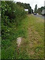
8
Old Milestone by the A631, Willingham Road, Market Rasen
Carved stone post by the A631, in parish of MARKET RASEN (WEST LINDSEY District), Willingham Road, on the verge, on South side of road. Rasen detail stone, erected by the Dexthorpe turnpike trust in the 19th century.
Inscription reads:-
: RASEN / ¾ M : : LOUTH / 14 :
Grade II listed. List Entry Number: 1246226
https://historicengland.org.uk/listing/the-list/list-entry/1246226
Milestone Society National ID: LI_LORS14.
Image: © Christine Minto
Taken: 26 Aug 2024
0.16 miles
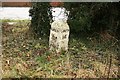
9
Old Milestone by the A631, Willingham Road, Market Rasen
Carved stone post by the A631, in parish of MARKET RASEN (WEST LINDSEY District), Willingham Road, on the verge, on South side of road. Rasen detail stone, erected by the Dexthorpe turnpike trust in the 19th century.
Inscription reads:-
: RASEN / ¾ M : : LOUTH / 14 :
Grade II listed. List Entry Number: 1246226
https://historicengland.org.uk/listing/the-list/list-entry/1246226
Milestone Society National ID: LI_LORS14.
Image: © Christine Minto
Taken: 26 Aug 2024
0.16 miles
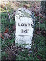
10
Turnpike milestone
One of a series of late 18th century milestones beside the A631, indicating ¾ mile to Rasen and 14 miles to Louth, installed after the road was turnpiked in 1765
Image: © Richard Croft
Taken: 5 Jan 2009
0.18 miles