IMAGES TAKEN NEAR TO
Willingham Road, MARKET RASEN, LN8 3DN
Introduction
This page details the photographs taken nearby to Willingham Road, LN8 3DN by members of the Geograph project.
The Geograph project started in 2005 with the aim of publishing, organising and preserving representative images for every square kilometre of Great Britain, Ireland and the Isle of Man.

There are currently over 7.5m images from over14,400 individuals and you can help contribute to the project by visiting https://www.geograph.org.uk
Image Map
Images are licensed for reuse under creativecommons.org/licenses/by-sa/2.0
Notes
- Clicking on the map will re-center to the selected point.
- The higher the marker number, the further away the image location is from the centre of the postcode.
Image Listing (138 Images Found)
Images are licensed for reuse under creativecommons.org/licenses/by-sa/2.0
Image
Details
Distance
1
Building site for new homes off Queen Street
Image: © JThomas
Taken: 8 Jun 2013
0.02 miles
2
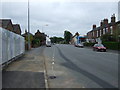
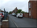
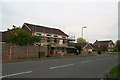
Queen Street (A631), Market Rasen
Heading east.
Image: © JThomas
Taken: 8 Jun 2013
0.03 miles
3
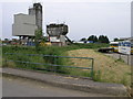
Concrete and River
This concrete plant stands by the banks of the River Rase which flows beneath the bridge.
Image: © Michael Patterson
Taken: 30 Jun 2006
0.05 miles
4
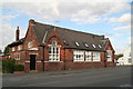
Old school on the corner of Pasture Lane (opposite the filling station)
Image: © Chris
Taken: 18 Aug 2013
0.07 miles
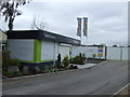
6
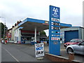
Service Station on Queen Street, Market Rasen
Image: © JThomas
Taken: 8 Jun 2013
0.07 miles
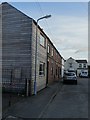
9
Building work in Jameson Bridge Street, by Victoria Road
Image: © Chris
Taken: 5 May 2014
0.09 miles
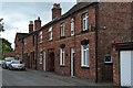
10
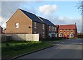
New houses on Pasture Lane, Market Rasen
Image: © Neil Theasby
Taken: 17 Apr 2015
0.09 miles