IMAGES TAKEN NEAR TO
Owmby Road, MARKET RASEN, LN8 2DD
Introduction
This page details the photographs taken nearby to Owmby Road, LN8 2DD by members of the Geograph project.
The Geograph project started in 2005 with the aim of publishing, organising and preserving representative images for every square kilometre of Great Britain, Ireland and the Isle of Man.

There are currently over 7.5m images from over14,400 individuals and you can help contribute to the project by visiting https://www.geograph.org.uk
Image Map
Images are licensed for reuse under creativecommons.org/licenses/by-sa/2.0
Notes
- Clicking on the map will re-center to the selected point.
- The higher the marker number, the further away the image location is from the centre of the postcode.
Image Listing (47 Images Found)
Images are licensed for reuse under creativecommons.org/licenses/by-sa/2.0
Image
Details
Distance
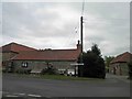
1
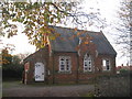
The Village Hall, Spridlington
The former village school.
Image: © Jonathan Thacker
Taken: 6 Nov 2010
0.06 miles
4
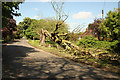
Fallen tree
A casualty of recent strong winds, on Owmby Road in Spridlington
Image: © Richard Croft
Taken: 25 May 2013
0.10 miles
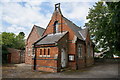
6
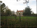
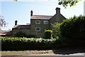
Church Farm, Spridlington
A large stone-built farmhouse in the centre of the village.
Image: © Jonathan Thacker
Taken: 6 Nov 2010
0.12 miles