IMAGES TAKEN NEAR TO
Fountain Street, MARKET RASEN, LN7 6UL
Introduction
This page details the photographs taken nearby to Fountain Street, LN7 6UL by members of the Geograph project.
The Geograph project started in 2005 with the aim of publishing, organising and preserving representative images for every square kilometre of Great Britain, Ireland and the Isle of Man.

There are currently over 7.5m images from over14,400 individuals and you can help contribute to the project by visiting https://www.geograph.org.uk
Image Map (Loading...)


Getting Data...Please wait
Leaflet Map data © OpenStreetMap
Images are licensed for reuse under creativecommons.org/licenses/by-sa/2.0
Notes
- Clicking on the map will re-center to the selected point.
- The higher the marker number, the further away the image location is from the centre of the postcode.
Image Listing (164 Images Found)
Images are licensed for reuse under creativecommons.org/licenses/by-sa/2.0
Image
Details
Distance
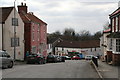
2
Fountain Street, Caistor
So named, presumably, because of the Syfer Spring, just out of sight at the end of the wall on the right. The site was said to cure eye problems. There are legends that the first local converts to Christianity were converted using the spring, which flows out of a brick restraining wall into a small pool. The water used to flow across the road into the brewery which used to be in the pink building on the left.
Image: © Paul Harrop
Taken: 24 Jun 2016
0.02 miles
3
Caistor - Fountain Street
So named, presumably, because of the Syfer Spring, just out of sight at the end of the wall on the right. The site was associated with eye problems. There are legends that the first local converts to Christianity were converted using the spring, which flows out of a brick restraining wall into a small pool. The water used to flow across the road into the brewery which used to be in the pink building on the left.
Image: © Paul Harrop
Taken: 24 Jun 2016
0.02 miles
4
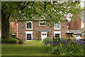
Country Georgian
Handsome early 19th century country Georgian house on Church Street seen from St.Peter & St.Paul's churchyard
Image: © Richard Croft
Taken: 8 May 2010
0.02 miles
5
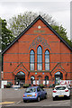
Caistor Arts and Heritage Centre, 28 Plough Hill, Caistor
The building started out as a Primitive Methodist Church in 1867 and was converted into a single storey youth facility almost 100 years later, before closing in 2005. The community took the opportunity to work with LCC in 2010 and negotiated a 25-year lease at a peppercorn rent. It was redesigned on two levels to maximise space and usage possibilities. This resulted in a building with a flexible exhibition/meeting space, library and café. The project received a Civic Award in 2011 and won an award from the Royal Institute of British Architects; one of only three buildings in the East Midlands to do so in recognition of its architectural excellence, designed by local architect Jonathan Hendry. It was funded by the Big Lottery Fund through Village SOS, a joint initiative with the BBC. The Caistor Arts & Heritage Centre (BIG) Ltd was set up as a not-for-profit social enterprise and received £430,000 of funding. The BBC filmed the project and created a one-hour documentary which was broadcast on BBC One TV in August 2011.
Image: © Jo and Steve Turner
Taken: 16 May 2015
0.02 miles
6
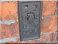
Ordnance Survey Flush Bracket S6419
This bracket can be found on the wall of the building currently being used as The Arts and Heritage Centre.
For more detail see : http://www.bench-marks.org.uk/bm13091
Image: © Peter Wood
Taken: 30 May 2012
0.02 miles

8
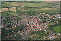
Caistor, aerial
Looking north. The historic market place is clearly visible. The area is well served with footpaths - the Viking Way runs right through the centre of town, but the only local bridleway is a miserly half-mile of track running right-left next to the set-aside field above the town.
Image: © Chris
Taken: 5 Aug 2007
0.03 miles
9
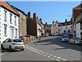
Plough Hill, Caistor
Leading up from the south side of the town towards Market Place
Image: © Paul Harrop
Taken: 24 Jun 2016
0.03 miles
