IMAGES TAKEN NEAR TO
Market Place, MARKET RASEN, LN7 6TU
Introduction
This page details the photographs taken nearby to Market Place, LN7 6TU by members of the Geograph project.
The Geograph project started in 2005 with the aim of publishing, organising and preserving representative images for every square kilometre of Great Britain, Ireland and the Isle of Man.

There are currently over 7.5m images from over14,400 individuals and you can help contribute to the project by visiting https://www.geograph.org.uk
Image Map
Images are licensed for reuse under creativecommons.org/licenses/by-sa/2.0
Notes
- Clicking on the map will re-center to the selected point.
- The higher the marker number, the further away the image location is from the centre of the postcode.
Image Listing (167 Images Found)
Images are licensed for reuse under creativecommons.org/licenses/by-sa/2.0
Image
Details
Distance
1
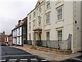
Plough Hill, Caistor
This house, built in the 1600s, is now an apartment block. It was spruced-up during the regeneration scheme and has kept (up to the time of this photograph) quite clean.
Image: © Dave Hitchborne
Taken: 13 Apr 2009
0.00 miles
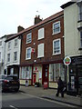
3
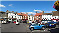
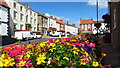
Market Place, Caistor
The large 17th century house has been turned into flats. To the right is the NatWest bank.
Image: © Dave Hitchborne
Taken: 13 Apr 2009
0.01 miles
4
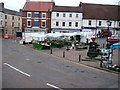
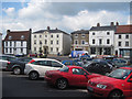
Caistor Market Place, Lincs
The elevated view from the top of a double-decker bus shows the content of the stalls at this now small Saturday market.
Image: © John Beal
Taken: 18 Aug 2007
0.02 miles
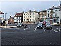
6
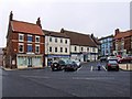
Market Place, Caistor
Where the Saturday market is held. The building to the left is a Pharmacy, then a Supermarket, a row of three terraced houses (of which only the end one can be seen), opposite which is The Cellars bar (up for sale) and then to the right of that is Caistor Loco, model railway shop.
Image: © Dave Hitchborne
Taken: 13 Apr 2009
0.02 miles
8
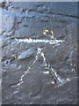
Ordnance Survey Cut Mark
This damaged OS cut mark can be found on the Bank in Market Place. It marks a point 93.918m above mean sea level.
Image: © Adrian Dust
Taken: 7 Nov 2013
0.02 miles
10
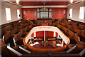
Wesleyan Chapel interior
Wonderful original 1842 box-pew gallery in the Methodist Chapel http://www.geograph.org.uk/photo/1861887
Image: © Richard Croft
Taken: 8 May 2010
0.02 miles