IMAGES TAKEN NEAR TO
Nettleton Top, MARKET RASEN, LN7 6SZ
Introduction
This page details the photographs taken nearby to LN7 6SZ by members of the Geograph project.
The Geograph project started in 2005 with the aim of publishing, organising and preserving representative images for every square kilometre of Great Britain, Ireland and the Isle of Man.

There are currently over 7.5m images from over14,400 individuals and you can help contribute to the project by visiting https://www.geograph.org.uk
Image Map (Loading...)


Getting Data...Please wait
Leaflet Map data © OpenStreetMap
Images are licensed for reuse under creativecommons.org/licenses/by-sa/2.0
Notes
- Clicking on the map will re-center to the selected point.
- The higher the marker number, the further away the image location is from the centre of the postcode.
Image Listing (13 Images Found)
Images are licensed for reuse under creativecommons.org/licenses/by-sa/2.0
Image
Details
Distance
1
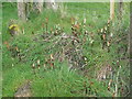
Horsetails near Nettleton Top
Can anyone identify the species ?
Image: © Jonathan Thacker
Taken: 22 Apr 2012
0.11 miles
2
View towards Oxgangs
Looking across the scarp of the Wolds.
Image: © Jonathan Thacker
Taken: 22 Apr 2012
0.13 miles
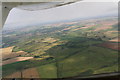
3
Across Normanby Road and Nettleton Top towards Nettleton Moor: aerial 2015
Mettleton Moor is in Image
Image: © Chris
Taken: 27 Dec 2015
0.17 miles
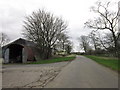
5

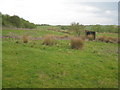
Road up to Nettleton Top
This private road cuts across the public footpath. The southwards route of the footpath begins again to the right of the photo.
Image: © Ian Paterson
Taken: 6 Apr 2008
0.18 miles
6
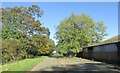
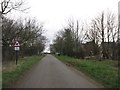
Lane at Nettleton Top
Walking to Nettleton.
Image: © steven ruffles
Taken: 15 Oct 2023
0.19 miles
7
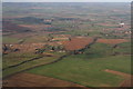
Old pasture of Nettleton (aerial 2012)
The bottom field is the one next to Oxgangs, see Image
This is the western escarpment of the Wolds, looking north towards Caistor. Mansgate Hill chalk quarry is in the top right corner. Oxgangs is just off the bottom right corner.
A permissive footpath (identified by other photos in this square as the "ironstone route") runs down through the field in the foreground from Nettleton Top and the ironstone workings.
A trail also runs round the edge of most of these fields.
The parallel rows of trees grouped left of centre, in the sunshine, mark the edges of the Slit Ponds.
See also Image for 2015 shot.
Image: © Chris
Taken: 2 Sep 2012
0.19 miles

10
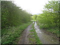
Ironstone route
The roadway constructed to transport ironstone away from the Nettleton mines descends the western scarp of the Wolds.
Image: © Jonathan Thacker
Taken: 22 Apr 2012
0.22 miles