IMAGES TAKEN NEAR TO
Audleby, MARKET RASEN, LN7 6RS
Introduction
This page details the photographs taken nearby to LN7 6RS by members of the Geograph project.
The Geograph project started in 2005 with the aim of publishing, organising and preserving representative images for every square kilometre of Great Britain, Ireland and the Isle of Man.

There are currently over 7.5m images from over14,400 individuals and you can help contribute to the project by visiting https://www.geograph.org.uk
Image Map
Images are licensed for reuse under creativecommons.org/licenses/by-sa/2.0
Notes
- Clicking on the map will re-center to the selected point.
- The higher the marker number, the further away the image location is from the centre of the postcode.
Image Listing (20 Images Found)
Images are licensed for reuse under creativecommons.org/licenses/by-sa/2.0
Image
Details
Distance
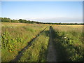
1
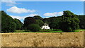
Audleby House near Clixby as seen from the Viking Way
Image: © Colin Park
Taken: 23 Aug 2021
0.00 miles
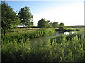
2
View towards Audelby
Taken from the Viking Way.
Image: © Jonathan Thacker
Taken: 19 Jun 2011
0.03 miles
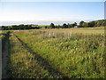
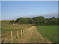
6
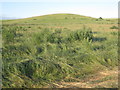
Wolds spur
The Viking Way runs along the edge of the Lincolnshire Wolds which rises quite abruptly from the Vale of Ancholme.
Image: © Jonathan Thacker
Taken: 19 Jun 2011
0.13 miles
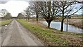
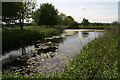
7
Pond at Audleby
Adjacent to the Viking Way.
Image: © Jonathan Thacker
Taken: 19 Jun 2011
0.13 miles
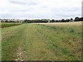
8
The Viking Way near Audleby
Here the Viking Way skirts the edge of the Lincolnshire Wolds.
Image: © Jonathan Thacker
Taken: 19 Jun 2011
0.14 miles
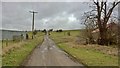
9
The Viking Way towards Audleby
Audleby is a hamlet in the parish of Caistor which runs to a farm and a couple of cottages.
Image: © Jonathan Thacker
Taken: 19 Jun 2011
0.15 miles